
Ein Besuch in Hkakabo Razi
Nützliche Informationen über Skigebiete, die Ihnen bei der Planung Ihrer Reise nach %{resort_name} helfen.
- Saison beginnt—
- Saison endet—
- Unterkunft—
- Restaurants | Bars— | —
- Nächster Flughafen Rangoon
- Nächster Bahnhof —
- Skigebiet Info-Website
- Infotelefon—
Merkmale Hkakabo Razi
Das Gelände in Hkakabo Razi umfasst:
- Halfpipes—
- Terrainparks—
- Langlauf—
- Skiverleih—
What's it like at Hkakabo Razi?
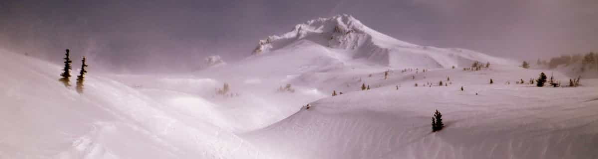
Hkakabo Razi is the highest mountain in Myanmar at 19,294 feet (5,881 metres and Myanmar was, until 1987, known as Burma.) The summit tip borders Tibet and India, also. The mountain is an extension of the Eastern Himalayas. Although low in comparison with Himalayan giants, Hkakabo Razi is perennially snow capped. Hkakabo Razi lies in the Hkakabo Razi protected area, established in 1996 which covers over 3812 square kilometres. Before 1993 this area was not accessable to foreigners. The first recorded attempt at the peak was made in 1995 by Takashai Ozaki, from Japan. He failed due to persistent bad weather. A year later he returned, and this time succeeded. Nyama Gyaltsen from Myanmar made it too. Like the main Himalayas, these mountains are heavily affected by the monsoon. Hkakabo Razi is certainly not a walk up. Huge cliffs with D+ climbing, hanging glaciers with large crevasses, and cornices, makes it a mountain not to be toyed with. The approach to the mountain is a major obstacle: there are unstable bridges, over huge gorges. For the most part, journeys are made on foot along footpaths that hug the mountainside and wind through dense jungle undergrowth. Ozaki demands four weeks walking to approach the base camp above 3000m/10000ft.
Hkakabo Razi entdecken – Lageplan
Interaktive Wanderkarte und Pistenplan für Hkakabo Razi. Für Ihre Tourenplanung sehen Sie Pisten und Wanderwege sowie Umrisse des Geländes und der Berge in der Umgebung.

In welchem Monat gibt es am meisten Schnee in Hkakabo Razi?
Wie ist der Schnee derzeit in Hkakabo Razi?
Eine Zusammenfassung der aktuellen Schneeverhältnisse in Hkakabo Razi. Weitere Informationen über Hkakabo Razi Seite detaillierter Schneebericht.
- Pistenbedingungen—
- Bedingungen jenseits der Pisten—

| Schneetiefe in Höhenlage: | ||
|---|---|---|
| Schneetiefe Tal: | ||
Besucher-Beurteilung fuer Hkakabo Razi
Roger aus Canada schreibt:
There was a plan to build a resort on this mountain led by former billionaire Thai Prime Minister Taksin. Of course, nothing came of it because it probably made little sense.
Lesen Sie 2 andere Beurteilungen ueber Hkakabo Razi oder geben Sie Ihre eigene Bewertung ab.
Skiorte in der Nähe von Hkakabo Razi
Entdecken Sie Skiorte in der Nähe von Hkakabo Razi. Klicken Sie unten, um die jeweiligen Reiseführer für Skiorte anzuzeigen
 Auli
Auli Changchengling Ski Resort
 Nearest