

Portillo Storm Snowfall Total Passes 5m / 17 Feet
A snow storm that has now continued for nine days has taken Chilean ski resort Portillo to a snowfall total of 5.2 metres (17 feet) so far, with more snow forecast.

Next 3 days weather summary:starker Regen (gesamt 20.0mm), stärkstens währ. der Nacht zu Freitag. Warm (maximal 28°C am Freitag Nachm., min 15°C in der Nacht zu Freitag). Der Wind bleibt meist schwach.. | Tage 4-6 Alpbachtal Wetter-ZusammenfassungMäßiger Regen (gesamt 15.0mm), stärkstens am Dienstag Nachm.. Warm (maximal 27°C am Montag Nachm., min 16°C in der Nacht zu Dienstag). Der Wind bleibt meist schwach.. | |||||||||||||||||
Donnerstag 30 | Freitag 31 | Samstag 1 | Sonntag 2 | Montag 3 | Dienstag 4 | |||||||||||||
AM | PM | Nacht | AM | PM | Nacht | AM | PM | Nacht | AM | PM | Nacht | AM | PM | Nacht | AM | PM | Nacht | |
klar | klar | klar | einige Wolken | einige Wolken | starker Regen | Schauer | Gewitter gefahr | etwas Regen | einige Wolken | einige Wolken | Schauer | einige Wolken | einige Wolken | Schauer | klar | Schauer | Schauer | |
km/h | ||||||||||||||||||
Schnee Karte |  |  |  |  |  |  | ||||||||||||
— | — | — | — | — | — | — | — | — | — | — | — | — | — | — | — | — | — | |
mm | — | — | — | — | — | 11 | 2 | 2 | 5 | — | — | 2 | — | — | 1 | — | 8 | 4 |
max °C | 23 | 27 | 24 | 25 | 28 | 20 | 19 | 23 | 19 | 22 | 25 | 21 | 24 | 27 | 21 | 22 | 22 | 17 |
min °C | 21 | 26 | 20 | 22 | 24 | 15 | 18 | 18 | 17 | 19 | 24 | 20 | 21 | 26 | 17 | 19 | 17 | 16 |
chill °C | 21 | 26 | 20 | 22 | 24 | 15 | 18 | 18 | 17 | 19 | 24 | 20 | 21 | 26 | 17 | 19 | 17 | 16 |
Feuchte % | 39 | 25 | 45 | 33 | 44 | 74 | 61 | 80 | 74 | 50 | 43 | 53 | 37 | 29 | 47 | 48 | 77 | 61 |
Gefrierpunkt m | 4350 | 4600 | 4500 | 4650 | 4600 | 4400 | 4300 | 4350 | 4300 | 4450 | 4600 | 4550 | 4550 | 4650 | 4450 | 4300 | 4250 | 4300 |
5:47 | — | — | 5:48 | — | — | 5:48 | — | — | 5:50 | — | — | 5:52 | — | — | 5:52 | — | — | |
— | — | 8:49 | — | — | 8:47 | — | — | 8:45 | — | — | 8:45 | — | — | 8:44 | — | — | 8:42 | |
Werde Profi und carve ein:
Lawineninformationen: European Avalanche Warning Services (EAWS)
Letzte Schneeberichte in der Nähe von Alpbachtal:
| Die obere Schneetiefe ist: | 0 cm |
|---|---|
| Die untere Schneetiefe ist: | 0 cm |
| Neuschneetiefe Berg | — |
| Wann hat es das letzte Mal geschneit? | 16 May 2026 |
0.0 | Bluebird Powder Tage Frischer Schnee, meist sonnig, leichter Wind. |
|---|---|
0.0 | Pulverschneetage Neuschnee, bewölkt, Wind |
0.0 | Bluebird Tage Schnee, meist sonnig, leichter Wind. |
Die Tabelle oben zeigt die Wettervorhersage für Alpbachtal auf der angegebenen Höhe von 1419 m. Unsere ausgeklügelten Wettermodelle ermöglichen uns die Schneevorhersage für die Gipfel-, Mittel- und Talstationen für Alpbachtal. Das Fenster über der Tabelle ermöglicht das Abrufen der Wettervorhersage für andere Höhen. Für einen umfassenderen Blick auf das Wetter, siehe die Wetterkarte" von Austria.Alpbachtal
Klicken Sie hier, um weitere Informationen über Gefrierpunkte zu erhalten und zu lesen wie wir unsere Temperaturen prognostizieren.
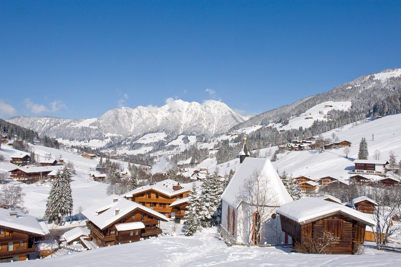
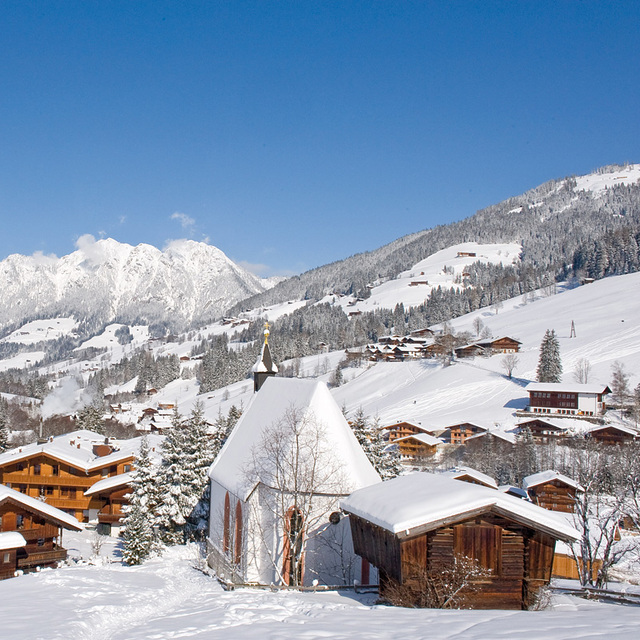
Skigebietsname wird auch Alpbach.geschrieben.
Allgemein 4.2 Basiert auf 22 Abstimmungen und 15 Beurteilungen
Back for our 15th year and probably 30 plus visits. Alpine charm at it's best. Winter and summer, always a fabulous welcoming and friendly place to visit.
Judith aus United Kingdom schreibt:
Back for our 15th year and probably 30 plus visits. Alpine charm at it's best. Winter and summer, always a fabulous welcoming and friendly place to visit.
Lesen Sie 14 andere Beurteilungen ueber Alpbachtal oder geben Sie Ihre eigene Bewertung ab.


 Nearest