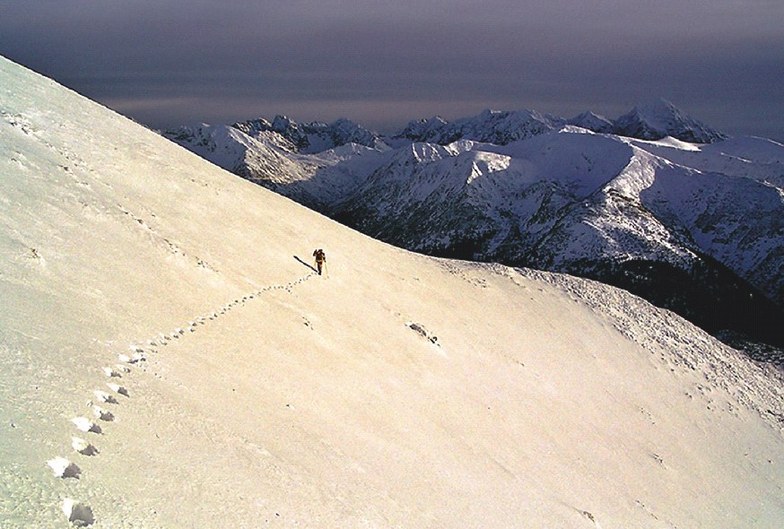


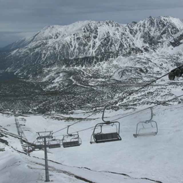
Portillo Storm Snowfall Total Passes 5m / 17 Feet
A snow storm that has now continued for nine days has taken Chilean ski resort Portillo to a snowfall total of 5.2 metres (17 feet) so far, with more snow forecast.

Next 3 days weather summary:leichter Regen (gesamt 4.0mm), meistens fallend am Dienstag Morg.. Warm (maximal 22°C am Donnerstag Nachm., min 9°C am Dienstag Morg.). Der Wind bleibt meist schwach.. | Tage 4-6 Zakopane Wetter-ZusammenfassungMeist trocken. Warm (maximal 26°C am Sonntag Nachm., min 22°C am Freitag Morg.). Der Wind bleibt meist schwach.. | |||||||||||||||||
Dienstag 28 | Mittwoch 29 | Donnerstag 30 | Freitag 31 | Samstag 1 | Sonntag 2 | |||||||||||||
AM | PM | Nacht | AM | PM | Nacht | AM | PM | Nacht | AM | PM | Nacht | AM | PM | Nacht | AM | PM | Nacht | |
Schauer | Schauer | klar | klar | einige Wolken | Schauer | klar | einige Wolken | klar | klar | einige Wolken | klar | einige Wolken | klar | einige Wolken | klar | einige Wolken | einige Wolken | |
km/h | ||||||||||||||||||
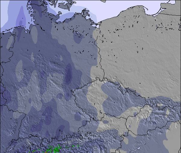
Schnee Karte |  |  |  | 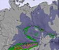 | 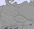 | 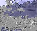 | ||||||||||||
— | — | — | — | — | — | — | — | — | — | — | — | — | — | — | — | — | — | |
mm | 2 | 1 | — | — | — | 1 | — | — | — | — | — | — | — | — | — | — | — | — |
max °C | 9 | 13 | 12 | 15 | 18 | 19 | 20 | 22 | 22 | 23 | 24 | 24 | 24 | 25 | 25 | 24 | 26 | 26 |
min °C | 9 | 12 | 12 | 12 | 17 | 17 | 19 | 21 | 21 | 22 | 24 | 23 | 23 | 25 | 22 | 22 | 26 | 25 |
chill °C | 7 | 10 | 11 | 12 | 17 | 17 | 19 | 21 | 21 | 22 | 24 | 23 | 23 | 25 | 22 | 22 | 26 | 25 |
Feuchte % | 88 | 65 | 61 | 53 | 54 | 43 | 45 | 42 | 36 | 31 | 30 | 27 | 28 | 28 | 32 | 32 | 27 | 24 |
Gefrierpunkt m | 2950 | 3400 | 3900 | 4000 | 4100 | 4150 | 4000 | 4100 | 4200 | 4250 | 4400 | 4550 | 4600 | 4550 | 4650 | 4650 | 4650 | 4650 |
5:05 | — | — | 5:05 | — | — | 5:07 | — | — | 5:09 | — | — | 5:09 | — | — | 5:11 | — | — | |
— | — | 8:25 | — | — | 8:24 | — | — | 8:23 | — | — | 8:22 | — | — | 8:21 | — | — | 8:19 | |
Werde Profi und carve ein:
Lawineninformationen: European Avalanche Warning Services (EAWS)
Letzte Schneeberichte in der Nähe von Zakopane:
| Die obere Schneetiefe ist: | 0 cm |
|---|---|
| Die untere Schneetiefe ist: | 0 cm |
| Neuschneetiefe Berg | — |
| Wann hat es das letzte Mal geschneit? | 17 May 2026 |
0.0 | Bluebird Powder Tage Frischer Schnee, meist sonnig, leichter Wind. |
|---|---|
0.0 | Pulverschneetage Neuschnee, bewölkt, Wind |
0.0 | Bluebird Tage Schnee, meist sonnig, leichter Wind. |

Die Tabelle oben zeigt die Wettervorhersage für Zakopane auf der angegebenen Höhe von 1496 m. Unsere ausgeklügelten Wettermodelle ermöglichen uns die Schneevorhersage für die Gipfel-, Mittel- und Talstationen für Zakopane. Das Fenster über der Tabelle ermöglicht das Abrufen der Wettervorhersage für andere Höhen. Für einen umfassenderen Blick auf das Wetter, siehe die Wetterkarte" von Poland.Zakopane
Klicken Sie hier, um weitere Informationen über Gefrierpunkte zu erhalten und zu lesen wie wir unsere Temperaturen prognostizieren.
Allgemein 4.0 Basiert auf 17 Abstimmungen und 25 Beurteilungen
We went to Zakopane as part of a trip of three guys (one a non skier) to see if we could go skiing from the Uk for less than £100. It was the end of the season but would recommend anyone to see what Zakopane has to offer. See how we got on from our video, search "jump wide" on Youtube for our experience.
Jump Wide aus United Kingdom schreibt:
We went to Zakopane as part of a trip of three guys (one a non skier) to see if we could go skiing from the Uk for less than £100. It was the end of the season but would recommend anyone to see what Zakopane has to offer. See how we got on from our video, search "jump wide" on Youtube for our experience.
Lesen Sie 24 andere Beurteilungen ueber Zakopane oder geben Sie Ihre eigene Bewertung ab.

 Nearest