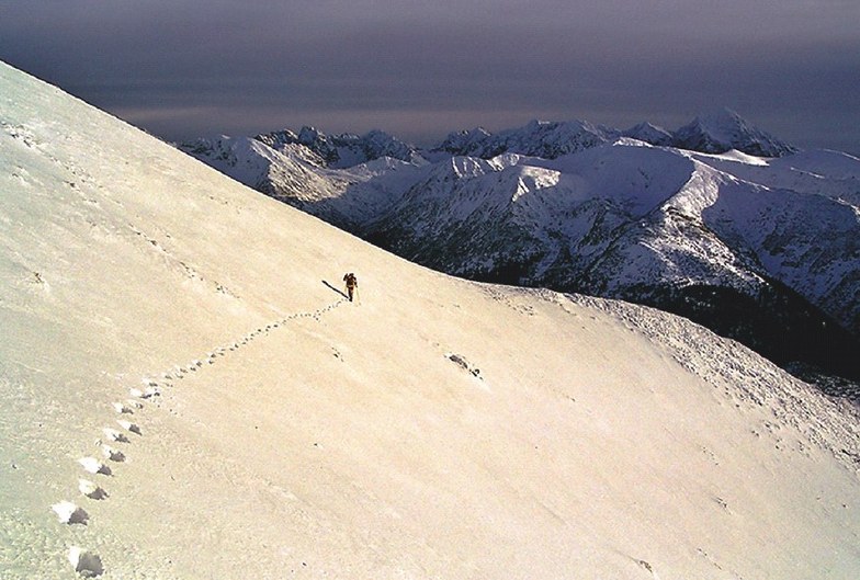


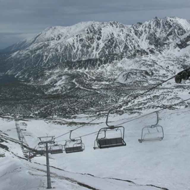
America’s Next Indoor Snow Centre Takes Shape
Construction of a new indoor snow centre for skiers, boarders and tubers appears to be making good progress at Heritage Farm in Wayne County, West Virginia.

Next 4 days weather summary:Mäßiger Regen (gesamt 10.0mm), stärkstens am Donnerstag Morg.. Sehr mild (maximal 15°C am Dienstag Nachm., min 7°C in der Nacht zu Montag). Der Wind bleibt meist schwach.. | Tage 5-7 Zakopane Wetter-Zusammenfassungleichter Regen (gesamt 8.0mm), meistens fallend in der Nacht zu Donnerstag. Warm (maximal 21°C am Sonntag Nachm., min 7°C in der Nacht zu Donnerstag). Der Wind bleibt meist schwach.. | |||||||||||||||
Dienstag 21 | Mittwoch 22 | Donnerstag 23 | Freitag 24 | Samstag 25 | ||||||||||||
Nacht | AM | PM | Nacht | AM | PM | Nacht | AM | PM | Nacht | AM | PM | Nacht | AM | PM | Nacht | |
klar | einige Wolken | einige Wolken | einige Wolken | Schauer | Schauer | etwas Regen | Schauer | Schauer | Schauer | etwas Regen | Schauer | einige Wolken | einige Wolken | bewölkt | einige Wolken | |
km/h | ||||||||||||||||
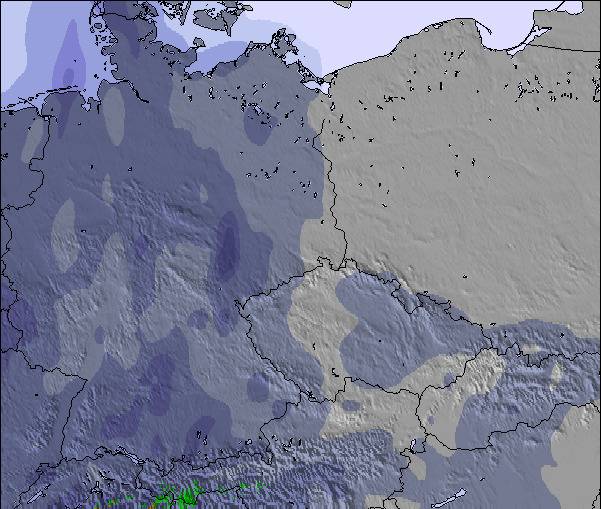
Schnee Karte |  |  |  | 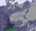 | 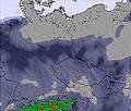 | 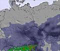 | ||||||||||
— | — | — | — | — | — | — | — | — | — | — | — | — | — | — | — | |
mm | — | — | — | — | 2 | 1 | 1 | 2 | 4 | 5 | 2 | 1 | — | — | — | — |
max °C | 11 | 14 | 15 | 10 | 12 | 14 | 11 | 12 | 13 | 8 | 8 | 10 | 9 | 16 | 16 | 13 |
min °C | 7 | 11 | 14 | 8 | 9 | 14 | 10 | 11 | 10 | 7 | 8 | 9 | 8 | 12 | 16 | 11 |
chill °C | 5 | 10 | 13 | 6 | 7 | 14 | 9 | 9 | 8 | 4 | 6 | 8 | 8 | 12 | 16 | 10 |
Feuchte % | 65 | 63 | 67 | 86 | 73 | 50 | 59 | 76 | 94 | 91 | 97 | 93 | 92 | 64 | 59 | 49 |
Gefrierpunkt m | 2750 | 2900 | 2900 | 2600 | 2550 | 2650 | 2700 | 2600 | 2500 | 2400 | 2450 | 2750 | 3000 | 2950 | 3050 | 3350 |
— | 4:56 | — | — | 4:58 | — | — | 4:58 | — | — | 5:00 | — | — | 5:01 | — | — | |
— | — | — | 8:35 | — | — | 8:34 | — | — | 8:32 | — | — | 8:30 | — | — | 8:30 | |
Werde Profi und carve ein:
Lawineninformationen: European Avalanche Warning Services (EAWS)
Letzte Schneeberichte in der Nähe von Zakopane:
| Die obere Schneetiefe ist: | 0 cm |
|---|---|
| Die untere Schneetiefe ist: | 0 cm |
| Neuschneetiefe Berg | — |
| Wann hat es das letzte Mal geschneit? | 17 May 2026 |
0.0 | Bluebird Powder Tage Frischer Schnee, meist sonnig, leichter Wind. |
|---|---|
0.0 | Pulverschneetage Neuschnee, bewölkt, Wind |
0.0 | Bluebird Tage Schnee, meist sonnig, leichter Wind. |

Die Tabelle oben zeigt die Wettervorhersage für Zakopane auf der angegebenen Höhe von 1031 m. Unsere ausgeklügelten Wettermodelle ermöglichen uns die Schneevorhersage für die Gipfel-, Mittel- und Talstationen für Zakopane. Das Fenster über der Tabelle ermöglicht das Abrufen der Wettervorhersage für andere Höhen. Für einen umfassenderen Blick auf das Wetter, siehe die Wetterkarte" von Poland.Zakopane
Klicken Sie hier, um weitere Informationen über Gefrierpunkte zu erhalten und zu lesen wie wir unsere Temperaturen prognostizieren.
Allgemein 4.0 Basiert auf 17 Abstimmungen und 25 Beurteilungen
We just had a family ski holiday to Zakopane and went with Sunshine World. I must admit, we were sceptical about the conditions and runs, but were so pleasantly surprised. The runs were managed so well and because it isn’t a very well-known area, by us Brits, there were no queues at the lifts. We loved the long blue at the back and the stops for warm beer were nice too. It’s great to see that they are making the place even better with two new lifts (not opened when we were there). There was plenty of snow and the runs were clean and wide, giving us newbies a better chance of not hitting anyone, haha. Sunshine World really made it for us, they organised everything for us, were completely professional and made it fun for us and our little ones. We loved being on the slopes and will definitely book with these guys for next year’s holiday.
Henry Wakeman aus United Kingdom schreibt:
We just had a family ski holiday to Zakopane and went with Sunshine World. I must admit, we were sceptical about the conditions and runs, but were so pleasantly surprised. The runs were managed so well and because it isn’t a very well-known area, by us Brits, there were no queues at the lifts. We loved the long blue at the back and the stops for warm beer were nice too. It’s great to see that they are making the place even better with two new lifts (not opened when we were there). There was plenty of snow and the runs were clean and wide, giving us newbies a better chance of not hitting anyone, haha. Sunshine World really made it for us, they organised everything for us, were completely professional and made it fun for us and our little ones. We loved being on the slopes and will definitely book with these guys for next year’s holiday.
Lesen Sie 24 andere Beurteilungen ueber Zakopane oder geben Sie Ihre eigene Bewertung ab.

 Nearest