Herausgegeben on Snow-Forecast.com um:7 am (lokale Zeit) / 01 Aug 2026
Letzte 6 TageScroll links für die letzten 6 TageJetzt
Next 3 days weather summary:
starker Regen (gesamt 27.0mm), stärkstens In der Nacht zu Freitag. Warm (maximal 26°C am Montag Nachm., min 16°C In der Nacht zu Samstag). Der Wind bleibt meist schwach..
Tage 4-6 Waidring Wetter-Zusammenfassung
starker Regen (gesamt 27.0mm), stärkstens In der Nacht zu Freitag. Warm (maximal 25°C am Dienstag Nachm., min 17°C in der Nacht zu Donnerstag). Der Wind bleibt meist schwach..
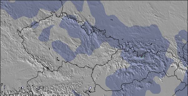
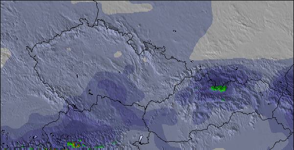
Die Tabelle oben zeigt die Wettervorhersage für Waidring auf der angegebenen Höhe von 1340 m. Unsere ausgeklügelten Wettermodelle ermöglichen uns die Schneevorhersage für die Gipfel-, Mittel- und Talstationen für Waidring. Das Fenster über der Tabelle ermöglicht das Abrufen der Wettervorhersage für andere Höhen. Für einen umfassenderen Blick auf das Wetter, siehe die Wetterkarte" von Austria.Waidring
Klicken Sie hier, um weitere Informationen über Gefrierpunkte zu erhalten und zu lesen wie wir unsere Temperaturen prognostizieren.
Besucher-Beurteilung fuer Waidring
Allgemein 3.9 Basiert auf 5 Abstimmungen und 3 Beurteilungen
Skied here several times, during Feb/March, as the snow was so much better than most other resorts, in the region, this year but it was often very busy because of this. Steinplatte is a great area for blue run skiers and there are some runs where even the most timid of skiers can allow their skis to stay in the foreline. The slopes are very wide and the lifts are very modern. As a consequence, when it is busy you really have to watch your back as there can be a large number of technically poor skiers hammering down the hill and it is sometimes quite dangerous to finish your turns because of the risk of someone skiing into you from behind. On quieter days, weekdays in January and just before Easter it is an intermediates paradise. If it gets too busy or the visibility is poor you can ski down to Winklmoos, in Germany, and usually avoid the queues and ski on tree-lined runs. This has the best terrain I have ever seen for beginners and very timid skiers afraid of any gradient, and holds the snow very well.
Pros: incredible terrain for timid skiers, usually the best snow conditions in the area, fast efficient lift system, easy to get to by car.
Cons: often very busy, a lot of idiot skiers, during the holidays, skiing too fast for their ability, not enough mountain restaurants which can get over-crowded, prone to misty whiteout conditions (most of the skiing is above the tree line).
Top tip: always ski here on a sunny weekday in low season.
Allgemein: 3.9 Basiert auf 5 Abstimmungen und 3 Beurteilungen
Schneesicher
4.6
Vielfalt der Pisten
3.6
Off Piste
3.0
Landschaft
4.2
Apres-Ski
3.4
Mark Gunston aus United Kingdom schreibt:
Skied here several times, during Feb/March, as the snow was so much better than most other resorts, in the region, this year but it was often very busy because of this. Steinplatte is a great area for blue run skiers and there are some runs where even the most timid of skiers can allow their skis to stay in the foreline. The slopes are very wide and the lifts are very modern. As a consequence, when it is busy you really have to watch your back as there can be a large number of technically poor skiers hammering down the hill and it is sometimes quite dangerous to finish your turns because of the risk of someone skiing into you from behind. On quieter days, weekdays in January and just before Easter it is an intermediates paradise. If it gets too busy or the visibility is poor you can ski down to Winklmoos, in Germany, and usually avoid the queues and ski on tree-lined runs. This has the best terrain I have ever seen for beginners and very timid skiers afraid of any gradient, and holds the snow very well.
Pros: incredible terrain for timid skiers, usually the best snow conditions in the area, fast efficient lift system, easy to get to by car.
Cons: often very busy, a lot of idiot skiers, during the holidays, skiing too fast for their ability, not enough mountain restaurants which can get over-crowded, prone to misty whiteout conditions (most of the skiing is above the tree line).
Top tip: always ski here on a sunny weekday in low season.
Kostenlose Snow-Forecast.com Wetter Widget für Ihre Website
Das Waidring Skiwetter Wideget unten, ist auf externen Seiten kostenlos eigebettet. Es bietet eine tägliche Zusammenfassung über unsere Waidring Schneevorhersage und derzeitige Wetterbedingungen. gehen Sie einfach auf die Feed-Konfiguration Seite und folgen Sie den 3 einfachen Schritten, um den eigenen HTML-Code-Snippet zu packen und fügen Sie ihn auf Ihrer eigenen Website. Sie können die Höhe der Schneevorhersage wählen (Gipfel, mittel Berg, oder unterer Gipfel) und Messeinheiten metrisch / Schneevorhersage für den Feed auf Ihre eigene Website & hellip anpassen; Klicken Sie hier, um den Code zu bekommen.


 Nearest