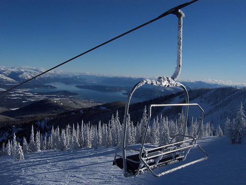


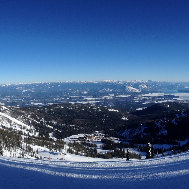
Portillo Storm Snowfall Total Passes 5m / 17 Feet
A snow storm that has now continued for nine days has taken Chilean ski resort Portillo to a snowfall total of 5.2 metres (17 feet) so far, with more snow forecast.

Next 3 days weather summary:Meist trocken. Warm (maximal 22°C am Freitag Nachm., min 14°C am Donnerstag Morg.). Der Wind bleibt meist schwach.. | Tage 4-6 Schweitzer Mountain Wetter-ZusammenfassungMeist trocken. Warm (maximal 20°C am Samstag Nachm., min 5°C am Sonntag Morg.). Wind abnehmend (fast Sturm aus SW am Samstag Nachm., Windstille bis Sonntag Nacht). | ||||||||||||||||
Mi 29 | Donnerstag 30 | Freitag 31 | Samstag 1 | Sonntag 2 | Montag 3 | ||||||||||||
PM | Nacht | AM | PM | Nacht | AM | PM | Nacht | AM | PM | Nacht | AM | PM | Nacht | AM | PM | Nacht | |
klar | einige Wolken | klar | klar | klar | klar | klar | klar | klar | klar | klar | klar | klar | klar | einige Wolken | einige Wolken | klar | |
km/h | |||||||||||||||||
Schnee Karte |  |  |  | 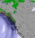 | 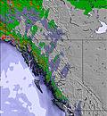 | 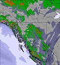 | |||||||||||
— | — | — | — | — | — | — | — | — | — | — | — | — | — | — | — | — | |
mm | — | — | — | — | — | — | — | — | — | — | — | — | — | — | — | — | — |
max °C | 17 | 17 | 15 | 19 | 19 | 17 | 22 | 22 | 19 | 20 | 16 | 8 | 13 | 12 | 9 | 14 | 13 |
min °C | 16 | 15 | 14 | 18 | 16 | 15 | 20 | 20 | 19 | 19 | 7 | 5 | 10 | 9 | 8 | 12 | 11 |
chill °C | 15 | 14 | 13 | 18 | 15 | 14 | 20 | 20 | 19 | 18 | 3 | 1 | 7 | 9 | 7 | 12 | 10 |
Feuchte % | 17 | 17 | 33 | 26 | 22 | 27 | 19 | 20 | 26 | 29 | 39 | 41 | 34 | 37 | 47 | 39 | 43 |
Gefrierpunkt m | 4200 | 4300 | 4250 | 4300 | 4550 | 4600 | 4800 | 5050 | 4800 | 4450 | 3750 | 3200 | 3350 | 3250 | 3100 | 3450 | 3450 |
— | — | 5:18 | — | — | 5:18 | — | — | 5:20 | — | — | 5:22 | — | — | 5:22 | — | — | |
— | 8:27 | — | — | 8:25 | — | — | 8:24 | — | — | 8:22 | — | — | 8:22 | — | — | 8:20 | |
Werde Profi und carve ein:
Lawineninformationen: National Avalanche Center
Letzte Schneeberichte in der Nähe von Schweitzer Mountain:
| Die obere Schneetiefe ist: | 0 cm |
|---|---|
| Die untere Schneetiefe ist: | 0 cm |
| Neuschneetiefe Berg | — |
| Wann hat es das letzte Mal geschneit? | 10 Jun 2026 |
0.0 | Bluebird Powder Tage Frischer Schnee, meist sonnig, leichter Wind. |
|---|---|
0.0 | Pulverschneetage Neuschnee, bewölkt, Wind |
0.0 | Bluebird Tage Schnee, meist sonnig, leichter Wind. |
Die Tabelle oben zeigt die Wettervorhersage für Schweitzer Mountain auf der angegebenen Höhe von 1950 m. Unsere ausgeklügelten Wettermodelle ermöglichen uns die Schneevorhersage für die Gipfel-, Mittel- und Talstationen für Schweitzer Mountain. Das Fenster über der Tabelle ermöglicht das Abrufen der Wettervorhersage für andere Höhen. Für einen umfassenderen Blick auf das Wetter, siehe die Wetterkarte" von United States.Schweitzer Mountain
Klicken Sie hier, um weitere Informationen über Gefrierpunkte zu erhalten und zu lesen wie wir unsere Temperaturen prognostizieren.
Allgemein 3.4 Basiert auf 24 Abstimmungen und 10 Beurteilungen
Not a good resort for the disabled. Parking is far away from the lifts. If you're disabled go elsewhere.
Pusbag aus United States schreibt:
Not a good resort for the disabled. Parking is far away from the lifts. If you're disabled go elsewhere.
Lesen Sie 9 andere Beurteilungen ueber Schweitzer Mountain oder geben Sie Ihre eigene Bewertung ab.

 Nearest