
Ein Besuch in Korjakskij
Nützliche Informationen über Skigebiete, die Ihnen bei der Planung Ihrer Reise nach %{resort_name} helfen.
- Saison beginnt—
- Saison endet—
- Unterkunft—
- Restaurants | Bars— | —
- Nächster Flughafen Elizovo
- Nächster Bahnhof —
- Skigebiet Info-Website
- Infotelefon—
Merkmale Korjakskij
Das Gelände in Korjakskij umfasst:
- HalfpipesN
- TerrainparksNo
- Langlauf18.0 km
- Skiverleih—
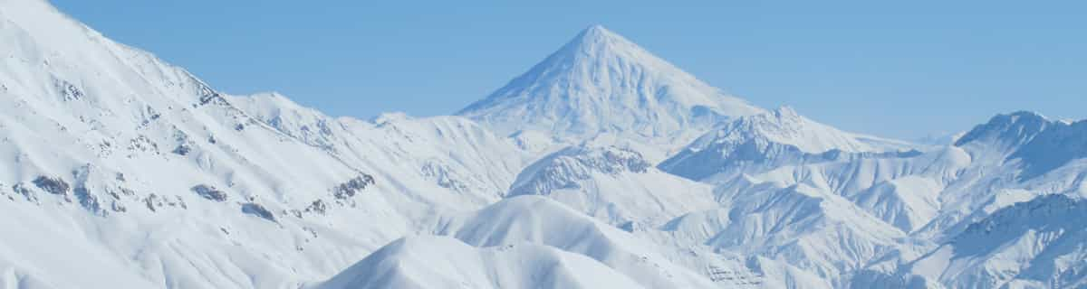
Wie sieht es in Korjakskij aus?
Korjakskij is the highest volcano of the volcanic range (Aag, Arik, Korjakskij, Avachinskaja, Uglovaja Kozelskij) situated 31km north-east from Petropavlovsk-Kamchatskij. Korjakskij is a typical stratovolcano with the regular ribbonated conus. There are no ski-lifts on the Korjaksij's slopes. In lower part you can skin up on skis with AT bindings, whereas on the upper part, crampons and ice-axe are needed. It is an area for advanced skiers only. There are several routes to the valley between volcanos Korjakskij and Avachinskaja, but other routes are to the Nalychevo valley or at the other side of the volcano. These extra routes are not used so often as the access is quite long. All routes are quite hard. Another possibility is to use a helicopter to take you up the summit but only in really nice weather (there is mostly very strong wind on the summit). Petropavlovsk-Kamchatskij - Korjakskij is about 31km. Three possible routes to the Korjakskij volcano. Route 4 is classical on the south-east rib, route 5 is through the main coloir, and route 6 is the fastest - it is often used for descending. All these routes started on the summit and finish at cottage camp, vertical difference is about 2600m. Nice route for cross-country skiing is in the valley of Sucha recka river - 18km. Other activities including snowmobiling, paragliding, etc.
Korjakskij entdecken – Lageplan
Interaktive Wanderkarte und Pistenplan für Korjakskij. Für Ihre Tourenplanung sehen Sie Pisten und Wanderwege sowie Umrisse des Geländes und der Berge in der Umgebung.

In welchem Monat gibt es am meisten Schnee in Korjakskij?
Wie ist der Schnee derzeit in Korjakskij?
Eine Zusammenfassung der aktuellen Schneeverhältnisse in Korjakskij. Weitere Informationen über Korjakskij Seite detaillierter Schneebericht.
- Pistenbedingungen—
- Bedingungen jenseits der Pisten—

| Schneetiefe in Höhenlage: | ||
|---|---|---|
| Schneetiefe Tal: | ||
Besucher-Beurteilung fuer Korjakskij
Skiorte in der Nähe von Korjakskij
Entdecken Sie Skiorte in der Nähe von Korjakskij. Klicken Sie unten, um die jeweiligen Reiseführer für Skiorte anzuzeigen
 Nearest