Letzte 6 TageScroll links für die letzten 6 TageJetzt
Next 4 days weather summary:
starker Regen (gesamt 29.0mm), stärkstens In der Nacht zu Freitag. Warm (maximal 21°C am Mittwoch Nachm., min 11°C in der Nacht zu Donnerstag). Wind zunehmend (Windstille in der Nacht zu Mittwoch, frische Winde aus WSW bis Donnerstag Nacht).
Tage 5-7 Torgon-Les Portes du Soleil Wetter-Zusammenfassung
Mäßiger Regen (gesamt 15.0mm), stärkstens in der Nacht zu Freitag. Sehr mild (maximal 16°C am Samstag Nachm., min 10°C in der Nacht zu Sonntag). Der Wind bleibt meist schwach..
Die Tabelle oben zeigt die Wettervorhersage für Torgon-Les Portes du Soleil auf der angegebenen Höhe von 1945 m. Unsere ausgeklügelten Wettermodelle ermöglichen uns die Schneevorhersage für die Gipfel-, Mittel- und Talstationen für Torgon-Les Portes du Soleil. Das Fenster über der Tabelle ermöglicht das Abrufen der Wettervorhersage für andere Höhen. Für einen umfassenderen Blick auf das Wetter, siehe die Wetterkarte" von Switzerland.Torgon-Les Portes du Soleil
Klicken Sie hier, um weitere Informationen über Gefrierpunkte zu erhalten und zu lesen wie wir unsere Temperaturen prognostizieren.
Besucher-Beurteilung fuer Torgon-Les Portes du Soleil
Allgemein 3.9 Basiert auf 11 Abstimmungen und 9 Beurteilungen
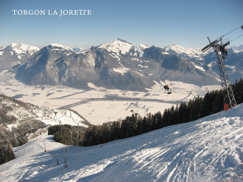
Torgon has really got it's act together and is now a smashing little starting off point for the whole Portes du Soleil.
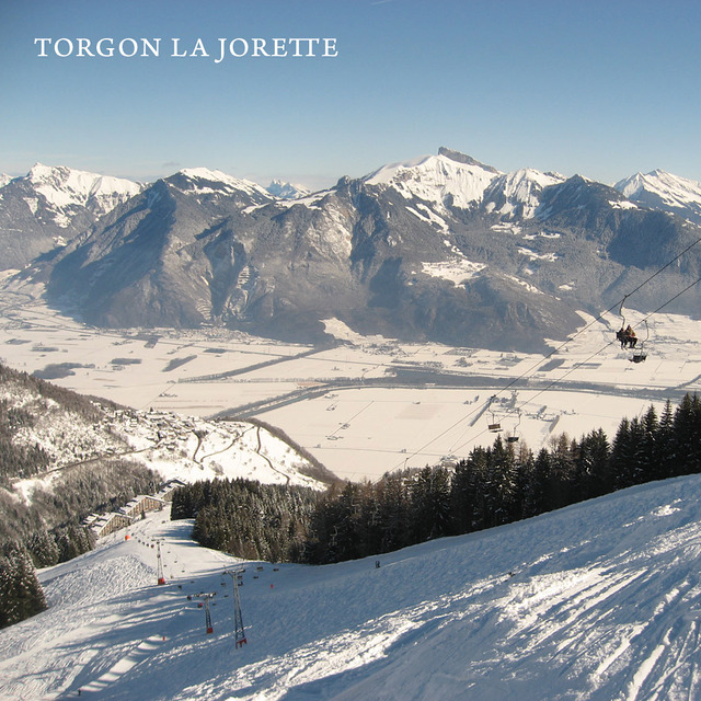
There is now a very regular navette to the main plain du croix ski area from the La Jorette village; something that was lacking in previous years.
When the snow comes, it has to be one of the best places in the whole domain. Lots of relatively untouched powdery runs await. While Chatel, Avoriaz and Les Gets are easily accessible and not to be missed, some of the nicest runs are towards La Chapelle.
When snow cover is poor, take the main Trenchey lift and head towards Chatel and beyond.
There is a new restaurant that seems to be an upmarket steak house and in the old village, the hotel de Torgon serves nice Belgian beer.
Beware that Torgon is very small and if it is closed for lack of snow early or late in the season there is not a lot to do! But if you have a car, you can still wind your way round the mountain to higher-up Champery and its cable car, so you will get some skiing. Torgon's relatively low altitude means this drive only takes about 45-50 mins.
Besucher-Beurteilung fuer Torgon-Les Portes du Soleil
Allgemein: 3.9 Basiert auf 11 Abstimmungen und 9 Beurteilungen
Schneesicher
3.6
Vielfalt der Pisten
4.5
Off Piste
4.1
Landschaft
4.4
Apres-Ski
3.2
peter aus Belgium schreibt:
Torgon has really got it's act together and is now a smashing little starting off point for the whole Portes du Soleil.
There is now a very regular navette to the main plain du croix ski area from the La Jorette village; something that was lacking in previous years.
When the snow comes, it has to be one of the best places in the whole domain. Lots of relatively untouched powdery runs await. While Chatel, Avoriaz and Les Gets are easily accessible and not to be missed, some of the nicest runs are towards La Chapelle.
When snow cover is poor, take the main Trenchey lift and head towards Chatel and beyond.
There is a new restaurant that seems to be an upmarket steak house and in the old village, the hotel de Torgon serves nice Belgian beer.
Beware that Torgon is very small and if it is closed for lack of snow early or late in the season there is not a lot to do! But if you have a car, you can still wind your way round the mountain to higher-up Champery and its cable car, so you will get some skiing. Torgon's relatively low altitude means this drive only takes about 45-50 mins.
Kostenlose Snow-Forecast.com Wetter Widget für Ihre Website
Das Torgon-Les Portes du Soleil Skiwetter Wideget unten, ist auf externen Seiten kostenlos eigebettet. Es bietet eine tägliche Zusammenfassung über unsere Torgon-Les Portes du Soleil Schneevorhersage und derzeitige Wetterbedingungen. gehen Sie einfach auf die Feed-Konfiguration Seite und folgen Sie den 3 einfachen Schritten, um den eigenen HTML-Code-Snippet zu packen und fügen Sie ihn auf Ihrer eigenen Website. Sie können die Höhe der Schneevorhersage wählen (Gipfel, mittel Berg, oder unterer Gipfel) und Messeinheiten metrisch / Schneevorhersage für den Feed auf Ihre eigene Website & hellip anpassen; Klicken Sie hier, um den Code zu bekommen.


 Nearest