Ein Besuch in Tateyama Sangaku
Nützliche Informationen über Skigebiete, die Ihnen bei der Planung Ihrer Reise nach %{resort_name} helfen.
- Saison beginnt—
- Saison endet—
- Unterkunft—
- Restaurants | Bars— | —
- Nächster Flughafen —
- Nächster Bahnhof —
- Skigebiet Info-Website—
- Infotelefon—
- Lawineninformationen:
Merkmale Tateyama Sangaku
Das Gelände in Tateyama Sangaku umfasst:
- Halfpipes—
- Terrainparks—
- Langlauf—
- Skiverleih—
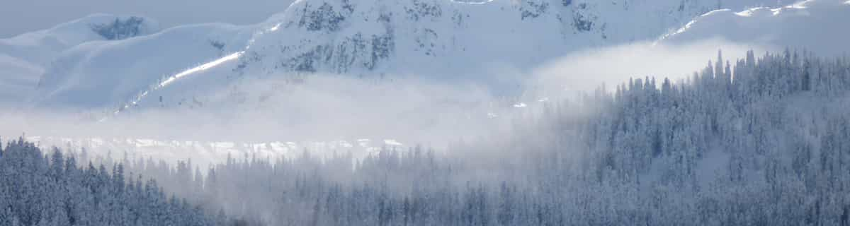
Wie sieht es in Tateyama Sangaku aus?
Tateyama Sangaku in Japan (located in the Toyama prefecture) is a minor ski resort but it does boast a very impressive 708 metres (2323 feet) of vertical descent. Tateyama Sangaku has 7 pistes. We have no information about the existence of any cross country ski trails at Tateyama Sangaku.
Tateyama Sangaku entdecken – Lageplan
Interaktive Wanderkarte und Pistenplan für Tateyama Sangaku. Für Ihre Tourenplanung sehen Sie Pisten und Wanderwege sowie Umrisse des Geländes und der Berge in der Umgebung.

In welchem Monat gibt es am meisten Schnee in Tateyama Sangaku?
Wie ist der Schnee derzeit in Tateyama Sangaku?
Eine Zusammenfassung der aktuellen Schneeverhältnisse in Tateyama Sangaku. Weitere Informationen über Tateyama Sangaku Seite detaillierter Schneebericht.
- Pistenbedingungen—
- Bedingungen jenseits der Pisten—

| Schneetiefe in Höhenlage: | ||
|---|---|---|
| Schneetiefe Tal: | ||
Besucher-Beurteilung fuer Tateyama Sangaku
Skiorte in der Nähe von Tateyama Sangaku
Entdecken Sie Skiorte in der Nähe von Tateyama Sangaku. Klicken Sie unten, um die jeweiligen Reiseführer für Skiorte anzuzeigen
 AshikurajiLetzter Schnee: 1.0 cm Tue 07 Apr
 Skilifte: 1
 Pisten: 21 km entfernt
- GokurakuzakaLetzter Schnee: 8.0 cm Tue 07 AprSkilifte: 5Pisten: 61 km entfernt
- Raicho ValleyLetzter Schnee: 8.0 cm Tue 07 AprSkilifte: 8Pisten: 32 km entfernt
- AwasunoLetzter Schnee: 8.0 cm Tue 07 AprSkilifte: 2Pisten: 33 km entfernt
- SarukurayamaLetzter Schnee: 4.0 cm Tue 10 MarSkilifte: 1Pisten: 117 km entfernt
 Nearest