
Ein Besuch in Popocatepetl
Nützliche Informationen über Skigebiete, die Ihnen bei der Planung Ihrer Reise nach %{resort_name} helfen.
- Saison beginnt—
- Saison endet—
- Unterkunft—
- Restaurants | Bars— | —
- Nächster Flughafen Mexico City
- Nächster Bahnhof —
- Skigebiet Info-Website—
- Infotelefon—
Merkmale Popocatepetl
Das Gelände in Popocatepetl umfasst:
- Halfpipes—
- Terrainparks—
- Langlauf—
- Skiverleih—
What's it like at Popocatepetl?
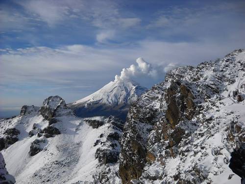
Popocatepetl is a volcano with forested slopes and a snow-capped cone and large crater. It is the second highest peak in Mexico at 17,887 feet (5452 metres) behind Pico de Orizaba at 18,405feet. The name Popocatepetl is Aztec for Smoking Mountain, and is often, conveniently, shortened to Popo. Popo and its neighboring volcano Iztaccihuatl (17,342 feet.) dominate the sky southeast of Mexico City. They are located less than fifty miles from the city, and are separated from each other by a ten mile ridge. Popo's last major eruption was in 1947, although on December 21st 1994, it awakened from dormancy, spewing gas and ash, which was carried by the wind as far as Puebla, 25 miles east. Surrounding towns were evacuated, and scientists have since been closely monitoring Popo for signs of a possible eruption. The first recorded ascent of Popocatepetl was by the Tecuanipas tribe in 1289. The first Spanish ascent of the mountain was an expedition led by Diego de Ordaz in 1519. Emperor Moctezuma sent ten warriors to climb the mountain sometime between 1502 and 1519. Only two of these warriors survived the climb.
Popocatepetl entdecken – Lageplan
Interaktive Wanderkarte und Pistenplan für Popocatepetl. Für Ihre Tourenplanung sehen Sie Pisten und Wanderwege sowie Umrisse des Geländes und der Berge in der Umgebung.

In welchem Monat gibt es am meisten Schnee in Popocatepetl?
Wie ist der Schnee derzeit in Popocatepetl?
Eine Zusammenfassung der aktuellen Schneeverhältnisse in Popocatepetl. Weitere Informationen über Popocatepetl Seite detaillierter Schneebericht.
- Pistenbedingungen—
- Bedingungen jenseits der Pisten—

| Schneetiefe in Höhenlage: | ||
|---|---|---|
| Schneetiefe Tal: | ||
Besucher-Beurteilung fuer Popocatepetl
Taylor Ramsay aus United States schreibt:
I cannot seem to find any information on how to ski at Popo or where there might be lifts. I read the most recent comment here from El Pico de Orizaba and felt hopeful, but I cannot find any further information. Does anyone have any more info?
Lesen Sie 3 andere Beurteilungen ueber Popocatepetl oder geben Sie Ihre eigene Bewertung ab.
Skiorte in der Nähe von Popocatepetl
Entdecken Sie Skiorte in der Nähe von Popocatepetl. Klicken Sie unten, um die jeweiligen Reiseführer für Skiorte anzuzeigen
 Ski ApacheLetzter Schnee: 1.0 cm Sat 02 May
 Skilifte: 11
 Pisten: 551732 km entfernt
- Mount Lemmon Ski ValleyLetzter Schnee: 2.0 cm Mon 09 MarSkilifte: 3Pisten: —1923 km entfernt
- Sandia PeakLetzter Schnee: 1.0 cm Tue 05 MaySkilifte: 7Pisten: 251955 km entfernt
- Sunrise Park ResortLetzter Schnee: 3.0 cm Tue 05 MaySkilifte: 10Pisten: 651983 km entfernt
- Ski Santa FeLetzter Schnee: 1.0 cm Tue 05 MaySkilifte: 6Pisten: 671984 km entfernt
 Nearest