

America’s Next Indoor Snow Centre Takes Shape
Construction of a new indoor snow centre for skiers, boarders and tubers appears to be making good progress at Heritage Farm in Wayne County, West Virginia.

Next 3 days weather summary:Mäßiger Regen (gesamt 10.0mm), stärkstens am Dienstag Nachm.. Sehr mild (maximal 10°C am Mittwoch Nachm., min 2°C in der Nacht zu Donnerstag). Der Wind bleibt meist schwach.. | Tage 4-6 Ortisei Wetter-ZusammenfassungMäßiger Regen (gesamt 17.0mm), stärkstens am Sonntag Nachm.. Sehr mild (maximal 12°C am Samstag Nachm., min 5°C in der Nacht zu Sonntag). Der Wind bleibt meist schwach.. | ||||||||||||||||
Di 21 | Mittwoch 22 | Donnerstag 23 | Freitag 24 | Samstag 25 | Sonntag 26 | ||||||||||||
PM | Nacht | AM | PM | Nacht | AM | PM | Nacht | AM | PM | Nacht | AM | PM | Nacht | AM | PM | Nacht | |
Gewitter gefahr | Schauer | klar | klar | Schauer | einige Wolken | etwas Regen | klar | klar | klar | einige Wolken | klar | klar | Schauer | Gewitter gefahr | Gewitter gefahr | Schauer | |
km/h | |||||||||||||||||
Schnee Karte |  |  |  |  |  |  | |||||||||||
— | — | — | — | — | — | — | — | — | — | — | — | — | — | — | — | — | |
mm | 5 | 3 | — | — | 1 | — | 1 | — | — | — | — | — | — | 2 | 2 | 12 | 1 |
max °C | 9 | 7 | 5 | 10 | 8 | 7 | 8 | 6 | 6 | 10 | 8 | 10 | 12 | 10 | 8 | 8 | 7 |
min °C | 8 | 3 | 4 | 8 | 5 | 5 | 8 | 2 | 4 | 9 | 6 | 8 | 11 | 7 | 7 | 7 | 5 |
chill °C | 7 | 2 | 3 | 7 | 4 | 3 | 7 | -1 | 1 | 8 | 5 | 7 | 10 | 4 | 6 | 4 | 1 |
Feuchte % | 75 | 68 | 54 | 50 | 72 | 57 | 58 | 62 | 32 | 35 | 63 | 51 | 61 | 79 | 83 | 91 | 66 |
Gefrierpunkt m | 3550 | 3250 | 3150 | 3750 | 3500 | 3300 | 3500 | 3050 | 3300 | 3950 | 3850 | 4000 | 4150 | 3900 | 3650 | 3650 | 3500 |
— | — | 5:41 | — | — | 5:41 | — | — | 5:43 | — | — | 5:45 | — | — | 5:46 | — | — | |
— | 8:58 | — | — | 8:57 | — | — | 8:55 | — | — | 8:54 | — | — | 8:53 | — | — | 8:52 | |
Werde Profi und carve ein:
Lawineninformationen: European Avalanche Warning Services (EAWS)
Letzte Schneeberichte in der Nähe von Ortisei:
| Die obere Schneetiefe ist: | — |
|---|---|
| Die untere Schneetiefe ist: | — |
| Neuschneetiefe Berg | — |
| Wann hat es das letzte Mal geschneit? | 10 Jun 2026 |
0.0 | Bluebird Powder Tage Frischer Schnee, meist sonnig, leichter Wind. |
|---|---|
0.0 | Pulverschneetage Neuschnee, bewölkt, Wind |
0.0 | Bluebird Tage Schnee, meist sonnig, leichter Wind. |
Die Tabelle oben zeigt die Wettervorhersage für Ortisei auf der angegebenen Höhe von 2518 m. Unsere ausgeklügelten Wettermodelle ermöglichen uns die Schneevorhersage für die Gipfel-, Mittel- und Talstationen für Ortisei. Das Fenster über der Tabelle ermöglicht das Abrufen der Wettervorhersage für andere Höhen. Für einen umfassenderen Blick auf das Wetter, siehe die Wetterkarte" von Italy.Ortisei
Klicken Sie hier, um weitere Informationen über Gefrierpunkte zu erhalten und zu lesen wie wir unsere Temperaturen prognostizieren.
Allgemein 4.3 Basiert auf 3 Abstimmungen und 1 Bewertung
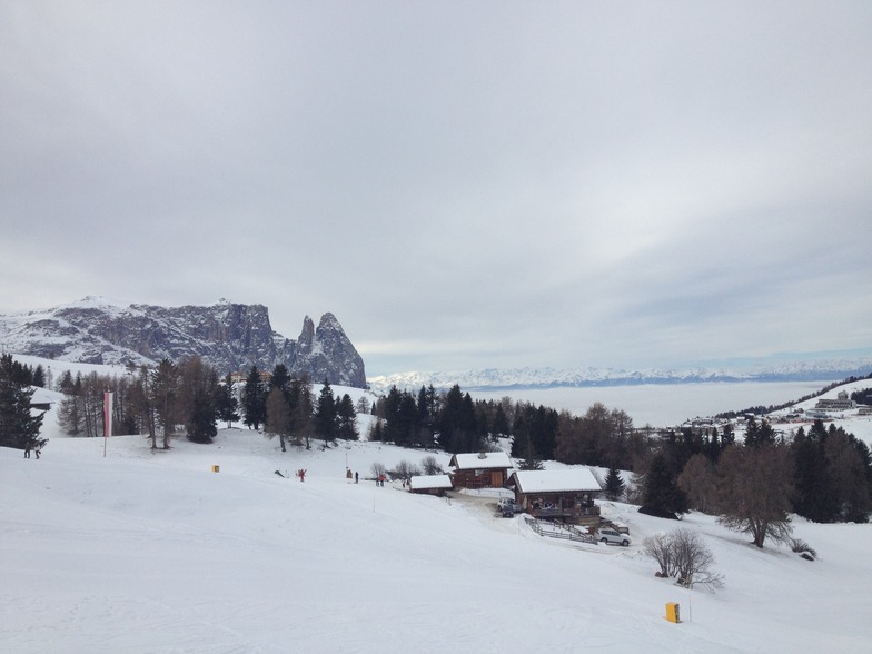
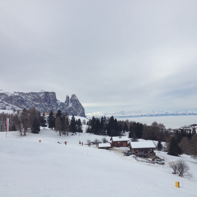
What a good place. We found a great apartment, at Ortisei, through the tourist office the morning we travelled (villa Prinoth). We drove from Bergamo which took about 3 hours. The resort has great amenities and escalators to drop you in the town or go to the lifts. Loads of pretty runs for snowboarding. Some good long ones and not too many flats. If it has snowed a lot take the single chair on the Seceda side instead of the gondola and you will get a pretty tree lined run all to yourself. If you want to do the Sella Ronda it is pretty easy going but the queues are bad on the lifts around the Wolkenstien. The igloo bar is ok. The bar staff are pretty and shake it to the music. Really worth going to Ortisei. Pretty runs, great scenery and the people are really friendly. Ortisei is a good antedote to some of the over priced French resorts.
Graeme Tucker aus United Kingdom schreibt:
What a good place. We found a great apartment, at Ortisei, through the tourist office the morning we travelled (villa Prinoth). We drove from Bergamo which took about 3 hours. The resort has great amenities and escalators to drop you in the town or go to the lifts. Loads of pretty runs for snowboarding. Some good long ones and not too many flats. If it has snowed a lot take the single chair on the Seceda side instead of the gondola and you will get a pretty tree lined run all to yourself. If you want to do the Sella Ronda it is pretty easy going but the queues are bad on the lifts around the Wolkenstien. The igloo bar is ok. The bar staff are pretty and shake it to the music. Really worth going to Ortisei. Pretty runs, great scenery and the people are really friendly. Ortisei is a good antedote to some of the over priced French resorts.
Klicken Sie hier um Ihre eigene Beurteilung über Ortisei abzugeben


 Nearest