Letzte 6 TageScroll links für die letzten 6 TageJetzt
Next 4 days weather summary:
starker Regen (gesamt 29.0mm), stärkstens In der Nacht zu Mittwoch. Warm (maximal 25°C am Freitag Nachm., min 16°C in der Nacht zu Mittwoch). Der Wind bleibt meist schwach..
Tage 5-7 Molveno Wetter-Zusammenfassung
starker Regen (gesamt 29.0mm), stärkstens In der Nacht zu Freitag. Warm (maximal 23°C in der Nacht zu Freitag, min 14°C in der Nacht zu Sonntag). Der Wind bleibt meist schwach..
Die Tabelle oben zeigt die Wettervorhersage für Molveno auf der angegebenen Höhe von 1196 m. Unsere ausgeklügelten Wettermodelle ermöglichen uns die Schneevorhersage für die Gipfel-, Mittel- und Talstationen für Molveno. Das Fenster über der Tabelle ermöglicht das Abrufen der Wettervorhersage für andere Höhen. Für einen umfassenderen Blick auf das Wetter, siehe die Wetterkarte" von Italy.Molveno
Klicken Sie hier, um weitere Informationen über Gefrierpunkte zu erhalten und zu lesen wie wir unsere Temperaturen prognostizieren.
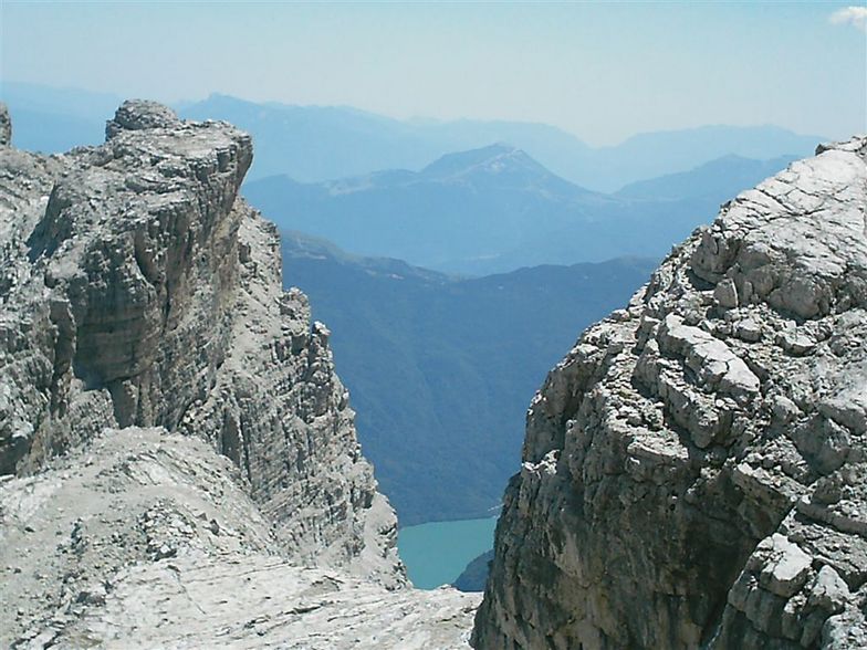
I have been living in the UK for 2 years now but am coming originally from Uganda where there is obviously no ability to ski, so coming to Molveno in March 2007 was a new experience for me. It was a small resort with only 1 piste but was perfect for me to learn to ski. The village of Molveno was very nice and quiet by a stunning blue lake and high mountains rising up behind. It is stated on this page that the bottom station is 864m but that is actually the village height, you have to get cable car from the village up a cliff to the bottom of the run at 1196m - what is called 'mid station' here. As Mr Brian Betonde found the cable car was not running from the village so we had to drive up too. This involves going up a dirt road through forest to reach a hotel car park which contains the lift station. There was not snow on the whole slope and no snow cannons to make artificial so some few parts we had to take off skis and walk down a small section of the slope to the next section of snow. This was not a problem for me as a beginner but I see an expert could find it limiting. Chairlift pass was around UG$86,000 which was about €90 at the time for 6 days, which I thought good value for the 1km run and having the slope to ourselves most time! I would reccommend Molveno to beginner and intermediate as long as you have friends to teach you, as there is no ski school.
I have been living in the UK for 2 years now but am coming originally from Uganda where there is obviously no ability to ski, so coming to Molveno in March 2007 was a new experience for me. It was a small resort with only 1 piste but was perfect for me to learn to ski. The village of Molveno was very nice and quiet by a stunning blue lake and high mountains rising up behind. It is stated on this page that the bottom station is 864m but that is actually the village height, you have to get cable car from the village up a cliff to the bottom of the run at 1196m - what is called 'mid station' here. As Mr Brian Betonde found the cable car was not running from the village so we had to drive up too. This involves going up a dirt road through forest to reach a hotel car park which contains the lift station. There was not snow on the whole slope and no snow cannons to make artificial so some few parts we had to take off skis and walk down a small section of the slope to the next section of snow. This was not a problem for me as a beginner but I see an expert could find it limiting. Chairlift pass was around UG$86,000 which was about €90 at the time for 6 days, which I thought good value for the 1km run and having the slope to ourselves most time! I would reccommend Molveno to beginner and intermediate as long as you have friends to teach you, as there is no ski school.
Kostenlose Snow-Forecast.com Wetter Widget für Ihre Website
Das Molveno Skiwetter Wideget unten, ist auf externen Seiten kostenlos eigebettet. Es bietet eine tägliche Zusammenfassung über unsere Molveno Schneevorhersage und derzeitige Wetterbedingungen. gehen Sie einfach auf die Feed-Konfiguration Seite und folgen Sie den 3 einfachen Schritten, um den eigenen HTML-Code-Snippet zu packen und fügen Sie ihn auf Ihrer eigenen Website. Sie können die Höhe der Schneevorhersage wählen (Gipfel, mittel Berg, oder unterer Gipfel) und Messeinheiten metrisch / Schneevorhersage für den Feed auf Ihre eigene Website & hellip anpassen; Klicken Sie hier, um den Code zu bekommen.


 Nearest