

Portillo Storm Snowfall Total Passes 5m / 17 Feet
A snow storm that has now continued for nine days has taken Chilean ski resort Portillo to a snowfall total of 5.2 metres (17 feet) so far, with more snow forecast.

Next 3 days weather summary:leichter Regen (gesamt 7.0mm), meistens fallend am Samstag Morgen. Warm (maximal 21°C am Donnerstag Nachm., min 15°C am Freitag Nachm.). Der Wind bleibt meist schwach.. | Tage 4-6 Les Gets Wetter-Zusammenfassungstarker Regen (gesamt 28.0mm), stärkstens währ. der Nacht zu Montag. Warm (maximal 21°C am Sonntag Nachm., min 14°C am Dienstag Morg.). Der Wind bleibt meist schwach.. | |||||||||||||||||
Donnerstag 30 | Freitag 31 | Samstag 1 | Sonntag 2 | Montag 3 | Dienstag 4 | |||||||||||||
AM | PM | Nacht | AM | PM | Nacht | AM | PM | Nacht | AM | PM | Nacht | AM | PM | Nacht | AM | PM | Nacht | |
klar | einige Wolken | einige Wolken | klar | Gewitter gefahr | Schauer | Gewitter gefahr | Schauer | klar | klar | klar | klar | klar | etwas Regen | starker Regen | Gewitter gefahr | Gewitter gefahr | Schauer | |
km/h | ||||||||||||||||||
Schnee Karte |  |  |  |  |  |  | ||||||||||||
— | — | — | — | — | — | — | — | — | — | — | — | — | — | — | — | — | — | |
mm | — | — | — | — | 1 | 2 | 3 | 1 | — | — | — | — | — | 1 | 14 | 3 | 6 | 4 |
max °C | 20 | 21 | 19 | 19 | 18 | 17 | 15 | 18 | 18 | 18 | 21 | 20 | 19 | 21 | 15 | 14 | 16 | 15 |
min °C | 18 | 20 | 19 | 19 | 15 | 16 | 15 | 17 | 16 | 16 | 20 | 18 | 18 | 19 | 15 | 14 | 15 | 14 |
chill °C | 18 | 20 | 19 | 19 | 15 | 16 | 15 | 17 | 16 | 16 | 20 | 18 | 18 | 19 | 15 | 14 | 15 | 14 |
Feuchte % | 25 | 39 | 41 | 43 | 69 | 59 | 65 | 49 | 47 | 40 | 38 | 50 | 44 | 56 | 59 | 67 | 65 | 66 |
Gefrierpunkt m | 4550 | 4550 | 4700 | 4650 | 4500 | 4400 | 4250 | 4400 | 4500 | 4450 | 4650 | 4550 | 4550 | 4550 | 4400 | 4150 | 4100 | 4150 |
6:11 | — | — | 6:13 | — | — | 6:13 | — | — | 6:15 | — | — | 6:16 | — | — | 6:18 | — | — | |
— | — | 9:06 | — | — | 9:05 | — | — | 9:04 | — | — | 9:01 | — | — | 9:00 | — | — | 9:00 | |
Werde Profi und carve ein:
Lawineninformationen: European Avalanche Warning Services (EAWS)
Letzte Schneeberichte in der Nähe von Les Gets:
| Die obere Schneetiefe ist: | — |
|---|---|
| Die untere Schneetiefe ist: | — |
| Neuschneetiefe Berg | — |
| Wann hat es das letzte Mal geschneit? | 16 May 2026 |
0.0 | Bluebird Powder Tage Frischer Schnee, meist sonnig, leichter Wind. |
|---|---|
0.0 | Pulverschneetage Neuschnee, bewölkt, Wind |
0.0 | Bluebird Tage Schnee, meist sonnig, leichter Wind. |
Die Tabelle oben zeigt die Wettervorhersage für Les Gets auf der angegebenen Höhe von 2002 m. Unsere ausgeklügelten Wettermodelle ermöglichen uns die Schneevorhersage für die Gipfel-, Mittel- und Talstationen für Les Gets. Das Fenster über der Tabelle ermöglicht das Abrufen der Wettervorhersage für andere Höhen. Für einen umfassenderen Blick auf das Wetter, siehe die Wetterkarte" von France.Les Gets
Klicken Sie hier, um weitere Informationen über Gefrierpunkte zu erhalten und zu lesen wie wir unsere Temperaturen prognostizieren.
Allgemein 4.3 Basiert auf 61 Abstimmungen und 36 Beurteilungen
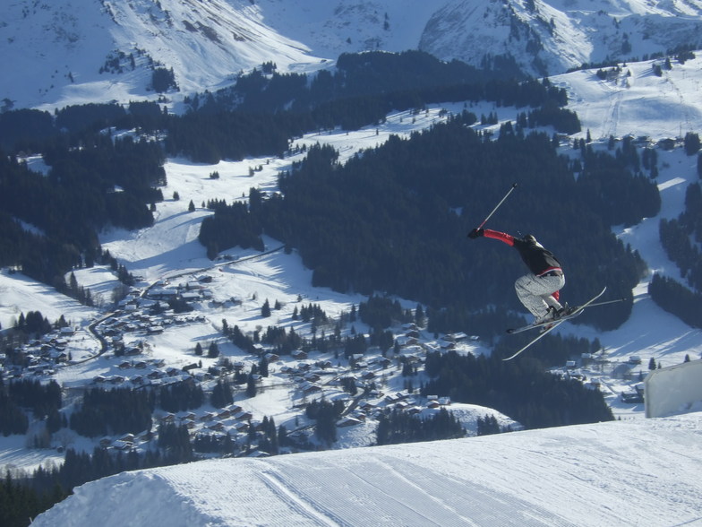
Great place for intermediates/beginners. 3 of us went at half term inc my 15 yr old son. We drove down to save on flight costs and self catered, brought 3 meals with us pre-prepared: all wine and beer, snacks etc, so made saving there as well. Took 14 hours but we stopped Friday night south of Dijon to sleep. Managed to get into Les Gets and on piste by 1pm on the Saturday. Stayed at the Perrriere end of the village to avoid crowds at Chavanne (half term); 2 min walk to lift, which was the best decision ever as we could get into the outback and ski fresh pisted runs in the morning before they got chopped up. It was a 15min walk to town but the bus goes every 15 mins and it was fine. Les Gets is a really nice place and we have been here 3 times now, 2 skiing and one summer. We have though outgrown it in terms of the skiing it offers and will be finding a higher resort for next year. But I would throughly recommend it and if you are looking for a ski holiday on a budget then look into driving; the whole week (6.5 days skiing) inc every single expense cost £3600 which at half term is unbelievable, and we still ate out at nice restaurants for 4 nights. We could have skied the Saturday as well but as the snow was not the best by then we decided to come home.
Phil - Bristol aus United Kingdom schreibt:
Great place for intermediates/beginners. 3 of us went at half term inc my 15 yr old son. We drove down to save on flight costs and self catered, brought 3 meals with us pre-prepared: all wine and beer, snacks etc, so made saving there as well. Took 14 hours but we stopped Friday night south of Dijon to sleep. Managed to get into Les Gets and on piste by 1pm on the Saturday. Stayed at the Perrriere end of the village to avoid crowds at Chavanne (half term); 2 min walk to lift, which was the best decision ever as we could get into the outback and ski fresh pisted runs in the morning before they got chopped up. It was a 15min walk to town but the bus goes every 15 mins and it was fine. Les Gets is a really nice place and we have been here 3 times now, 2 skiing and one summer. We have though outgrown it in terms of the skiing it offers and will be finding a higher resort for next year. But I would throughly recommend it and if you are looking for a ski holiday on a budget then look into driving; the whole week (6.5 days skiing) inc every single expense cost £3600 which at half term is unbelievable, and we still ate out at nice restaurants for 4 nights. We could have skied the Saturday as well but as the snow was not the best by then we decided to come home.
Lesen Sie 35 andere Beurteilungen ueber Les Gets oder geben Sie Ihre eigene Bewertung ab.


 Nearest