

America’s Next Indoor Snow Centre Takes Shape
Construction of a new indoor snow centre for skiers, boarders and tubers appears to be making good progress at Heritage Farm in Wayne County, West Virginia.

Next 3 days weather summary:leichter Regen (gesamt 4.0mm), meistens fallend am Dienstag Nachm.. Sehr mild (maximal 19°C am Mittwoch Nachm., min 7°C in der Nacht zu Dienstag). Der Wind bleibt meist schwach.. | Tage 4-6 Chandolin Wetter-Zusammenfassungstarker Regen (gesamt 29.0mm), stärkstens In der Nacht zu Freitag. Warm (maximal 23°C am Samstag Nachm., min 7°C in der Nacht zu Sonntag). Der Wind bleibt meist schwach.. | ||||||||||||||||
Di 21 | Mittwoch 22 | Donnerstag 23 | Freitag 24 | Samstag 25 | Sonntag 26 | ||||||||||||
PM | Nacht | AM | PM | Nacht | AM | PM | Nacht | AM | PM | Nacht | AM | PM | Nacht | AM | PM | Nacht | |
Gewitter gefahr | Schauer | klar | klar | einige Wolken | einige Wolken | einige Wolken | klar | klar | klar | klar | klar | Gewitter gefahr | starker Regen | Schauer | Schauer | Schauer | |
km/h | |||||||||||||||||
Schnee Karte |  |  |  |  |  |  | |||||||||||
— | — | — | — | — | — | — | — | — | — | — | — | — | — | — | — | — | |
mm | 3 | 1 | — | — | — | — | — | — | — | — | — | — | 1 | 17 | 4 | 4 | 3 |
max °C | 18 | 13 | 15 | 19 | 15 | 15 | 18 | 14 | 17 | 21 | 17 | 20 | 23 | 14 | 14 | 15 | 12 |
min °C | 17 | 7 | 10 | 18 | 8 | 11 | 18 | 7 | 11 | 20 | 10 | 14 | 20 | 10 | 11 | 14 | 7 |
chill °C | 17 | 7 | 10 | 18 | 8 | 11 | 18 | 7 | 11 | 20 | 10 | 14 | 20 | 10 | 11 | 14 | 7 |
Feuchte % | 51 | 74 | 39 | 35 | 60 | 44 | 36 | 66 | 24 | 25 | 56 | 31 | 46 | 96 | 70 | 67 | 83 |
Gefrierpunkt m | 3600 | 3600 | 3850 | 3900 | 3800 | 3600 | 3750 | 3950 | 4200 | 4250 | 4400 | 4350 | 4150 | 3550 | 3500 | 3550 | 3500 |
— | — | 5:58 | — | — | 6:00 | — | — | 6:01 | — | — | 6:01 | — | — | 6:03 | — | — | |
— | 9:13 | — | — | 9:12 | — | — | 9:10 | — | — | 9:09 | — | — | 9:08 | — | — | 9:07 | |
Werde Profi und carve ein:
Lawineninformationen: European Avalanche Warning Services (EAWS)
Letzte Schneeberichte in der Nähe von Chandolin:
| Die obere Schneetiefe ist: | 0 cm |
|---|---|
| Die untere Schneetiefe ist: | 0 cm |
| Neuschneetiefe Berg | — |
| Wann hat es das letzte Mal geschneit? | 10 Jun 2026 |
0.0 | Bluebird Powder Tage Frischer Schnee, meist sonnig, leichter Wind. |
|---|---|
0.0 | Pulverschneetage Neuschnee, bewölkt, Wind |
0.0 | Bluebird Tage Schnee, meist sonnig, leichter Wind. |


Die Tabelle oben zeigt die Wettervorhersage für Chandolin auf der angegebenen Höhe von 1650 m. Unsere ausgeklügelten Wettermodelle ermöglichen uns die Schneevorhersage für die Gipfel-, Mittel- und Talstationen für Chandolin. Das Fenster über der Tabelle ermöglicht das Abrufen der Wettervorhersage für andere Höhen. Für einen umfassenderen Blick auf das Wetter, siehe die Wetterkarte" von Switzerland.Chandolin
Klicken Sie hier, um weitere Informationen über Gefrierpunkte zu erhalten und zu lesen wie wir unsere Temperaturen prognostizieren.
Allgemein 3.8 Basiert auf 14 Abstimmungen und 3 Beurteilungen
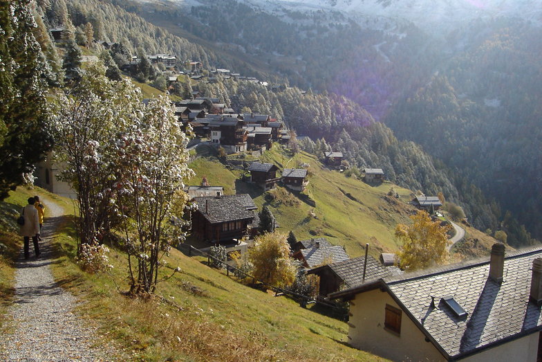
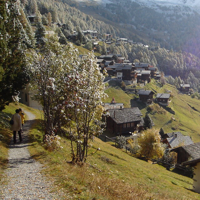
Chandolin is a sleepy little village located high on a sunny bench, precariously perched above the Val d'Anniviers. The ski area is shared with St. Luc, a bigger village with better lift access a few k's back along the road. Since Chandolin is arguably the highest village in Switzerland the road can be very slippery, especially after sunny afternoons have allowed a bit of runoff. The resort is tiny, nightlife non-existent and the lifts are antiquated yet it is still one of my favorite places in Switzerland. The combined ski area is respectably big, invariably quiet, sunny, and after new snow, the off-pitse is excellent. Lack of crowds mean that it can stay that way for several days, especially through the trees. Views are spectacular and lift tickets reasonably affordable. The old part of the village is especially picturesque. All in all it is an excellent place from which to explore the diverse and largely undiscovered slopes of the Anniviers Valley. It is helpful to have your own transport if that's your plan.
Rob aus United Kingdom schreibt:
Chandolin is a sleepy little village located high on a sunny bench, precariously perched above the Val d'Anniviers. The ski area is shared with St. Luc, a bigger village with better lift access a few k's back along the road. Since Chandolin is arguably the highest village in Switzerland the road can be very slippery, especially after sunny afternoons have allowed a bit of runoff.
The resort is tiny, nightlife non-existent and the lifts are antiquated yet it is still one of my favorite places in Switzerland. The combined ski area is respectably big, invariably quiet, sunny, and after new snow, the off-pitse is excellent. Lack of crowds mean that it can stay that way for several days, especially through the trees. Views are spectacular and lift tickets reasonably affordable. The old part of the village is especially picturesque. All in all it is an excellent place from which to explore the diverse and largely undiscovered slopes of the Anniviers Valley. It is helpful to have your own transport if that's your plan.
Lesen Sie 2 andere Beurteilungen ueber Chandolin oder geben Sie Ihre eigene Bewertung ab.


 Nearest