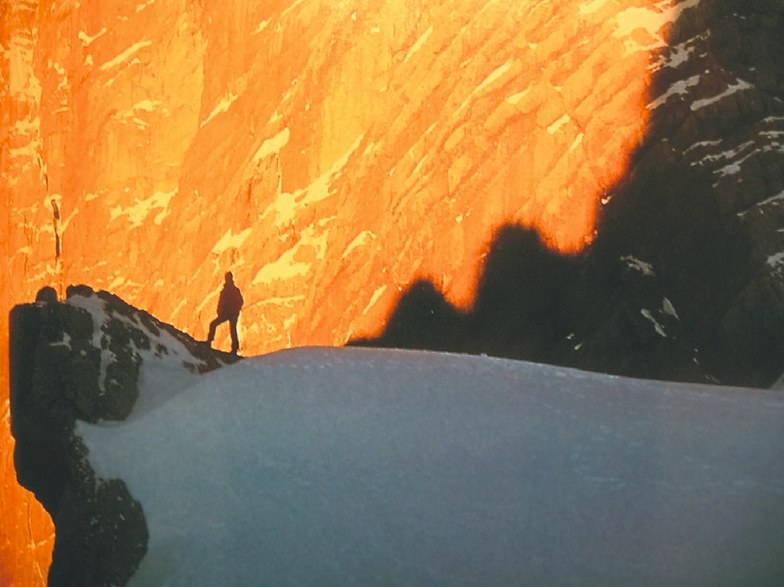


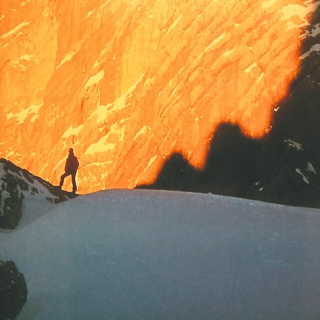
Portillo Re-Opens To Guests Arriving By Helicopter
Chile’s famous Portillo ski resort is reported to have re-opened to guests arriving by helicopter after being cut off by road for more than two weeks by over 6m/20 feet of snowfall.

Next 3 days weather summary:etwas Nieselregen, stärkstens In der Nacht zu Freitag. Warm (maximal 23°C in der Nacht zu Mittwoch, min 19°C am Dienstag Morg.). Der Wind bleibt meist schwach.. | Tage 4-6 Brentonico Wetter-ZusammenfassungMäßiger Regen (gesamt 18.0mm), stärkstens in der Nacht zu Freitag. Warm (maximal 23°C am Donnerstag Nachm., min 16°C am Samstag Morgen). Der Wind bleibt meist schwach.. | ||||||||||||||||
Mo 3 | Dienstag 4 | Mittwoch 5 | Donnerstag 6 | Freitag 7 | Samstag 8 | ||||||||||||
PM | Nacht | AM | PM | Nacht | AM | PM | Nacht | AM | PM | Nacht | AM | PM | Nacht | AM | PM | Nacht | |
klar | einige Wolken | klar | klar | Schauer | klar | klar | klar | klar | klar | etwas Regen | Gewitter gefahr | Gewitter gefahr | Schauer | klar | Gewitter gefahr | Schauer | |
km/h | |||||||||||||||||
Schnee Karte |  |  |  |  |  |  | |||||||||||
— | — | — | — | — | — | — | — | — | — | — | — | — | — | — | — | — | |
mm | — | — | — | — | 1 | — | — | — | — | — | 3 | 1 | 2 | 5 | — | 2 | 5 |
max °C | 22 | 22 | 19 | 22 | 22 | 19 | 22 | 23 | 20 | 23 | 21 | 18 | 20 | 20 | 16 | 19 | 19 |
min °C | 21 | 20 | 19 | 21 | 19 | 19 | 21 | 20 | 20 | 22 | 19 | 17 | 20 | 17 | 16 | 18 | 17 |
chill °C | 21 | 20 | 19 | 21 | 19 | 19 | 21 | 20 | 20 | 22 | 19 | 17 | 20 | 17 | 16 | 18 | 17 |
Feuchte % | 35 | 41 | 52 | 40 | 51 | 56 | 41 | 48 | 51 | 34 | 49 | 64 | 56 | 59 | 69 | 60 | 68 |
Gefrierpunkt m | 4450 | 4400 | 4400 | 4500 | 4450 | 4550 | 4650 | 4500 | 4400 | 4550 | 4500 | 4300 | 4250 | 4300 | 4250 | 4250 | 4300 |
— | — | 6:01 | — | — | 6:03 | — | — | 6:03 | — | — | 6:05 | — | — | 6:05 | — | — | |
— | 8:43 | — | — | 8:42 | — | — | 8:39 | — | — | 8:38 | — | — | 8:37 | — | — | 8:36 | |
Werde Profi und carve ein:
Lawineninformationen: European Avalanche Warning Services (EAWS)
Letzte Schneeberichte in der Nähe von Brentonico:
| Die obere Schneetiefe ist: | — |
|---|---|
| Die untere Schneetiefe ist: | — |
| Neuschneetiefe Berg | — |
| Wann hat es das letzte Mal geschneit? | 15 May 2026 |
0.0 | Bluebird Powder Tage Frischer Schnee, meist sonnig, leichter Wind. |
|---|---|
0.0 | Pulverschneetage Neuschnee, bewölkt, Wind |
0.0 | Bluebird Tage Schnee, meist sonnig, leichter Wind. |
Die Tabelle oben zeigt die Wettervorhersage für Brentonico auf der angegebenen Höhe von 1700 m. Unsere ausgeklügelten Wettermodelle ermöglichen uns die Schneevorhersage für die Gipfel-, Mittel- und Talstationen für Brentonico. Das Fenster über der Tabelle ermöglicht das Abrufen der Wettervorhersage für andere Höhen. Für einen umfassenderen Blick auf das Wetter, siehe die Wetterkarte" von Italy.Brentonico
Klicken Sie hier, um weitere Informationen über Gefrierpunkte zu erhalten und zu lesen wie wir unsere Temperaturen prognostizieren.
I am from the Czech republic. I was in this small resort close to the Brenner-Adige highway last week with my parents. We had a bon chance - week before was a heavy snowfall all over northern Italy, so the skiing was perfect. Skiing takes place on two hills somewhat over 1500m high. One is La Polsa, the other part of the resort is San Valentino/San Giacommo. In L Polsa, there is one new 4person chairlift, under which is a very, very wide carving slope (310m drop on 1300m of length.) Very nice, from 10 to 5pm, under southern sun. There is also one engine-powered lift on the left side of the resort. There is a good opportunity to take some safe steps off-piste (as under you are normal meadows, no risk of avalanche etc.) Connection of the hills: very old, one-post, chair lift. Museal, but you will get into liking it ;-) And another opportunity for off-piste on a steep north/east meadow under the lift. San Valentino is one 4 person chairlift with a couple of runs being served by it. Again, somewhat about 300m of drop. Some very sporty runs with beautiful snow, protected from wind, with sun only about midday. There are also some less standard, steep-black versions. And two nearly 2km blue/red downhills. As a bonus to these resorts is skiing in Pra Alpesina (1400-1800m) - cca 10km of runs on a high mountain right above beautiful Lago di Garda. You have to drive some half an hour on twisty mountain road to reach it. There is one oldish monoposto lift, one beautiful steep black run (drop cca 380m) facing east and a couple of other lifts, where also beginners will find their luck. And you can have coffee in a restaurant, white stuff all around you, blue sky above and blue lake deep, deep under you...you´ll not forget this. If you will have luck for good snow, you will not get bored in this area for at least 4-5 days, as we did.
Valodja aus United Kingdom schreibt:
I am from the Czech republic. I was in this small resort close to the Brenner-Adige highway last week with my parents. We had a bon chance - week before was a heavy snowfall all over northern Italy, so the skiing was perfect. Skiing takes place on two hills somewhat over 1500m high. One is La Polsa, the other part of the resort is San Valentino/San Giacommo. In L Polsa, there is one new 4person chairlift, under which is a very, very wide carving slope (310m drop on 1300m of length.) Very nice, from 10 to 5pm, under southern sun. There is also one engine-powered lift on the left side of the resort. There is a good opportunity to take some safe steps off-piste (as under you are normal meadows, no risk of avalanche etc.) Connection of the hills: very old, one-post, chair lift. Museal, but you will get into liking it ;-) And another opportunity for off-piste on a steep north/east meadow under the lift. San Valentino is one 4 person chairlift with a couple of runs being served by it. Again, somewhat about 300m of drop. Some very sporty runs with beautiful snow, protected from wind, with sun only about midday. There are also some less standard, steep-black versions. And two nearly 2km blue/red downhills. As a bonus to these resorts is skiing in Pra Alpesina (1400-1800m) - cca 10km of runs on a high mountain right above beautiful Lago di Garda. You have to drive some half an hour on twisty mountain road to reach it. There is one oldish monoposto lift, one beautiful steep black run (drop cca 380m) facing east and a couple of other lifts, where also beginners will find their luck. And you can have coffee in a restaurant, white stuff all around you, blue sky above and blue lake deep, deep under you...you´ll not forget this. If you will have luck for good snow, you will not get bored in this area for at least 4-5 days, as we did.
Klicken Sie hier um Ihre eigene Beurteilung über Brentonico abzugeben


 Nearest