
Global Weekly Snow Roundup #324
Weekly Snow News for World, updated 23 July 2026: South America’s 2026 season roars back with over 4m (13ft) of snowfall, while Saas-Fee opens and North America’s last lift-served skiing ends.

Next 3 days weather summary:Mäßiger Regen (gesamt 15.0mm), stärkstens In der Nacht zu Samstag. Sehr mild (maximal 16°C am Samstag Nachm., min 8°C am Sonntag Morg.). Der Wind bleibt meist schwach.. | Tage 4-6 Avoriaz Wetter-ZusammenfassungMäßiger Regen (gesamt 12.0mm), stärkstens am Sonntag Nachm.. Sehr mild (maximal 17°C am Dienstag Nachm., min 7°C in der Nacht zu Sonntag). Der Wind bleibt meist schwach.. | ||||||||||||||||
Do 23 | Freitag 24 | Samstag 25 | Sonntag 26 | Montag 27 | Dienstag 28 | ||||||||||||
PM | Nacht | AM | PM | Nacht | AM | PM | Nacht | AM | PM | Nacht | AM | PM | Nacht | AM | PM | Nacht | |
klar | klar | klar | klar | klar | einige Wolken | klar | starker Regen | Gewitter gefahr | Schauer | Schauer | klar | klar | klar | klar | klar | klar | |
km/h | |||||||||||||||||
Schnee Karte |  |  |  |  |  |  | |||||||||||
— | — | — | — | — | — | — | — | — | — | — | — | — | — | — | — | — | |
mm | — | — | — | — | — | — | — | 13 | 2 | 9 | 3 | — | — | — | — | — | — |
max °C | 11 | 10 | 12 | 15 | 14 | 15 | 16 | 12 | 9 | 10 | 9 | 9 | 12 | 13 | 15 | 17 | 17 |
min °C | 10 | 9 | 10 | 14 | 13 | 14 | 16 | 9 | 8 | 9 | 7 | 7 | 11 | 12 | 13 | 16 | 15 |
chill °C | 9 | 8 | 10 | 14 | 12 | 13 | 16 | 7 | 7 | 8 | 6 | 7 | 10 | 12 | 13 | 16 | 15 |
Feuchte % | 51 | 34 | 27 | 31 | 30 | 33 | 50 | 78 | 78 | 72 | 86 | 60 | 60 | 39 | 33 | 43 | 64 |
Gefrierpunkt m | 3500 | 3950 | 4350 | 4400 | 4450 | 4300 | 4150 | 3750 | 3550 | 3600 | 3550 | 3850 | 3900 | 4750 | 4700 | 4650 | 4550 |
— | — | 6:03 | — | — | 6:05 | — | — | 6:05 | — | — | 6:07 | — | — | 6:09 | — | — | |
— | 9:14 | — | — | 9:13 | — | — | 9:12 | — | — | 9:10 | — | — | 9:09 | — | — | 9:07 | |
Werde Profi und carve ein:
Lawineninformationen: European Avalanche Warning Services (EAWS)
Letzte Schneeberichte in der Nähe von Avoriaz:
| Die obere Schneetiefe ist: | 0 cm |
|---|---|
| Die untere Schneetiefe ist: | 0 cm |
| Neuschneetiefe Berg | — |
| Wann hat es das letzte Mal geschneit? | 16 May 2026 |
0.0 | Bluebird Powder Tage Frischer Schnee, meist sonnig, leichter Wind. |
|---|---|
0.1 | Pulverschneetage Neuschnee, bewölkt, Wind |
0.0 | Bluebird Tage Schnee, meist sonnig, leichter Wind. |
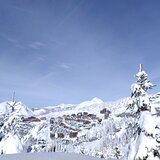
Die Tabelle oben zeigt die Wettervorhersage für Avoriaz auf der angegebenen Höhe von 2254 m. Unsere ausgeklügelten Wettermodelle ermöglichen uns die Schneevorhersage für die Gipfel-, Mittel- und Talstationen für Avoriaz. Das Fenster über der Tabelle ermöglicht das Abrufen der Wettervorhersage für andere Höhen. Für einen umfassenderen Blick auf das Wetter, siehe die Wetterkarte" von France.Avoriaz
Klicken Sie hier, um weitere Informationen über Gefrierpunkte zu erhalten und zu lesen wie wir unsere Temperaturen prognostizieren.
Allgemein 4.2 Basiert auf 63 Abstimmungen und 43 Beurteilungen
The skiing center absolutely cannot handle the capacity of people. There is nowhere to eat, poor service, no services in the evening except for a couple of bars, the slopes are crowded. I do not recommend.
David aus Czechia schreibt:
The skiing center absolutely cannot handle the capacity of people. There is nowhere to eat, poor service, no services in the evening except for a couple of bars, the slopes are crowded. I do not recommend.
Lesen Sie 42 andere Beurteilungen ueber Avoriaz oder geben Sie Ihre eigene Bewertung ab.


 Nearest