Herausgegeben on Snow-Forecast.com um:7 pm (lokale Zeit) / 02 Aug 2026
Letzte 6 TageScroll links für die letzten 6 TageJetzt
Next 4 days weather summary:
leichter Regen (gesamt 8.0mm), meistens fallend in der Nacht zu Sonntag. Sehr mild (maximal 19°C am Mittwoch Nachm., min 12°C in der Nacht zu Sonntag). Der Wind bleibt meist schwach..
Tage 5-7 Alpe di Siusi Wetter-Zusammenfassung
starker Regen (gesamt 39.0mm), stärkstens währ. Donnerstag Nachm.. Sehr mild (maximal 18°C am Donnerstag Nachm., min 12°C in der Nacht zu Donnerstag). Der Wind bleibt meist schwach..
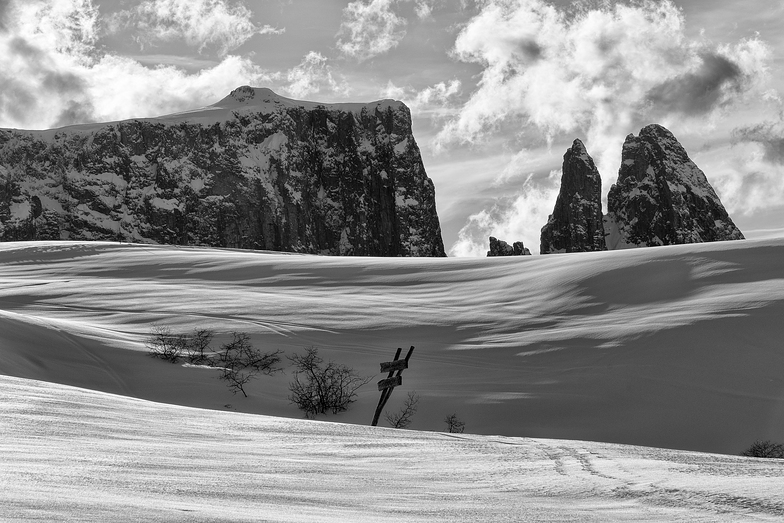
Die Tabelle oben zeigt die Wettervorhersage für Alpe di Siusi auf der angegebenen Höhe von 2210 m. Unsere ausgeklügelten Wettermodelle ermöglichen uns die Schneevorhersage für die Gipfel-, Mittel- und Talstationen für Alpe di Siusi. Das Fenster über der Tabelle ermöglicht das Abrufen der Wettervorhersage für andere Höhen. Für einen umfassenderen Blick auf das Wetter, siehe die Wetterkarte" von Italy.Alpe di Siusi
Klicken Sie hier, um weitere Informationen über Gefrierpunkte zu erhalten und zu lesen wie wir unsere Temperaturen prognostizieren.
Skigebietsname wird auch Alpe Di Siusi.geschrieben.
Besucher-Beurteilung fuer Alpe di Siusi
Allgemein 4.1 Basiert auf 14 Abstimmungen und 1 Bewertung
We have skied Alpe Di Siusi 2 years, both times in February. It is a lovely resort with great beginner and intermediate conditions. Not crowded, very scenic and picturesque. I love the wonderful Italian food available in the many small restaurants on the slopes. I am advanced/expert and so there is not much to challenge me but the entire Val Gardena area is close by and you can buy a Dolomite superski pass. One negative is, because the resort was built in organic fashion (used to be individual hotels with their own lifts), there is a bit more of flat areas between lifts than I would like. But it is a great family ski destination.
Allgemein: 4.1 Basiert auf 14 Abstimmungen und 1 Bewertung
Schneesicher
4.0
Vielfalt der Pisten
3.9
Off Piste
4.5
Landschaft
5.0
Apres-Ski
3.2
peter thomson aus The Netherlands schreibt:
We have skied Alpe Di Siusi 2 years, both times in February. It is a lovely resort with great beginner and intermediate conditions. Not crowded, very scenic and picturesque. I love the wonderful Italian food available in the many small restaurants on the slopes. I am advanced/expert and so there is not much to challenge me but the entire Val Gardena area is close by and you can buy a Dolomite superski pass. One negative is, because the resort was built in organic fashion (used to be individual hotels with their own lifts), there is a bit more of flat areas between lifts than I would like. But it is a great family ski destination.
Kostenlose Snow-Forecast.com Wetter Widget für Ihre Website
Das Alpe di Siusi Skiwetter Wideget unten, ist auf externen Seiten kostenlos eigebettet. Es bietet eine tägliche Zusammenfassung über unsere Alpe di Siusi Schneevorhersage und derzeitige Wetterbedingungen. gehen Sie einfach auf die Feed-Konfiguration Seite und folgen Sie den 3 einfachen Schritten, um den eigenen HTML-Code-Snippet zu packen und fügen Sie ihn auf Ihrer eigenen Website. Sie können die Höhe der Schneevorhersage wählen (Gipfel, mittel Berg, oder unterer Gipfel) und Messeinheiten metrisch / Schneevorhersage für den Feed auf Ihre eigene Website & hellip anpassen; Klicken Sie hier, um den Code zu bekommen.


 Nearest