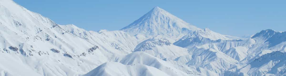


Global Weekly Snow Roundup #314
Weekly Global Snow News, updated 14 May 2026: Fresh snowfall in Argentina, Australia and Lesotho signals winter’s approach, while Japan maintains the world’s deepest snowpack.

Next 3 days weather summary:leichter Regen (gesamt 8.0mm), meistens fallend In der Nacht zu Samstag. Warm (maximal 22°C am Montag Nachm., min 9°C in der Nacht zu Sonntag). Wind schwächt ab. | Days 4-6 weather summary:Mäßiger Regen (gesamt 17.0mm), stärkstens in der Nacht zu Dienstag. Warm (maximal 24°C am Dienstag Nachm., min 3°C in der Nacht zu Mittwoch). Wind abnehmend (frische Winde aus WSW in der Nacht zu Dienstag, Windstille bis Donnerstag Nacht). | |||||||||||||||||
Saturday 16 | Sunday 17 | Monday 18 | Tuesday 19 | Wednesday 20 | Thursday 21 | |||||||||||||
AM | PM | Nacht | AM | PM | Nacht | AM | PM | Nacht | AM | PM | Nacht | AM | PM | Nacht | AM | PM | Nacht | |
einige Wolken | einige Wolken | Schauer | etwas Regen | einige Wolken | einige Wolken | bewölkt | einige Wolken | klar | Gewittergefahr | Gewittergefahr | Schauer | Gewittergefahr | etwas Regen | etwas Regen | einige Wolken | einige Wolken | einige Wolken | |
km/h | ||||||||||||||||||
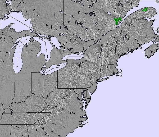
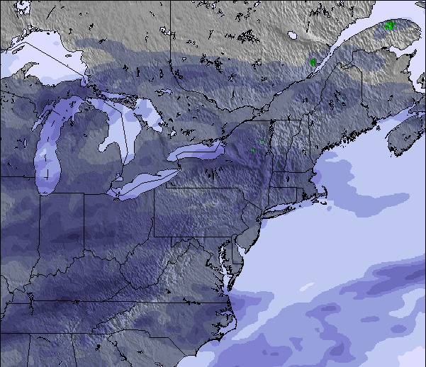
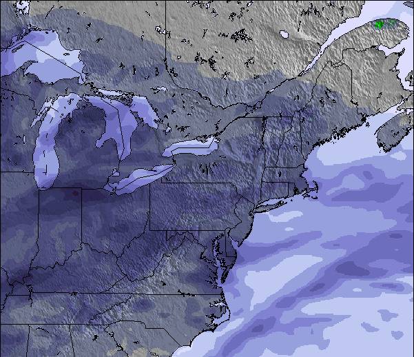
Snow map |  |  |  |  |  |  | ||||||||||||
— | — | — | — | — | — | — | — | — | — | — | — | — | — | — | — | — | — | |
— | — | 7 | 1 | — | — | — | — | — | 2 | 2 | 5 | 2 | 4 | 2 | — | — | — | |
max °C | 15 | 19 | 14 | 14 | 15 | 12 | 13 | 22 | 20 | 20 | 24 | 22 | 20 | 19 | 14 | 7 | 10 | 9 |
min °C | 12 | 17 | 12 | 12 | 14 | 9 | 12 | 18 | 18 | 20 | 22 | 18 | 19 | 18 | 3 | 4 | 9 | 5 |
10 | 16 | 10 | 10 | 12 | 9 | 12 | 18 | 18 | 20 | 22 | 18 | 19 | 17 | 0 | 0 | 7 | 4 | |
56 | 55 | 95 | 67 | 60 | 73 | 65 | 61 | 85 | 90 | 74 | 89 | 92 | 97 | 88 | 60 | 50 | 57 | |
3000 | 3300 | 2800 | 2700 | 3050 | 3600 | 3600 | 4150 | 4100 | 4300 | 4200 | 4000 | 3950 | 3750 | 1400 | 1050 | 1450 | 1400 | |
5:18 | — | — | 5:18 | — | — | 5:16 | — | — | 5:16 | — | — | 5:15 | — | — | 5:13 | — | — | |
— | — | 8:14 | — | — | 8:15 | — | — | 8:15 | — | — | 8:16 | — | — | 8:19 | — | — | 8:20 | |
Letzte Schneeberichte in der Nähe von Ski Bromont:
| Die obere Schneetiefe ist: | — |
|---|---|
| Die untere Schneetiefe ist: | — |
| Neuschneetiefe Berg | — |
| Wann hat es das letzte Mal geschneit? | 20 Apr 2026 |
0.0 | Bluebird Powder Tage Frischer Schnee, meist sonnig, leichter Wind. |
|---|---|
0.0 | Pulverschneetage Neuschnee, bewölkt, Wind |
0.0 | Bluebird Tage Schnee, meist sonnig, leichter Wind. |
Die Tabelle oben zeigt die Wettervorhersage für Ski Bromont auf der angegebenen Höhe von 370 m. Unsere ausgeklügelten Wettermodelle ermöglichen uns die Schneevorhersage für die Gipfel-, Mittel- und Talstationen für Ski Bromont. Das Fenster über der Tabelle ermöglicht das Abrufen der Wettervorhersage für andere Höhen. Für einen umfassenderen Blick auf das Wetter, siehe die Wetterkarte" von Canada.Ski Bromont
Klicken Sie hier, um weitere Informationen über Gefrierpunkte zu erhalten und zu lesen wie wir unsere Temperaturen prognostizieren.
Allgemein 3.2 Basiert auf 9 Abstimmungen und 3 Beurteilungen
Great potential wasted. Bromont is just 1hr driving from Montreal, on the south shore. There are plenty of varied slopes for all levels of skiers. The chalets (base and top) are recent or renovated, the slopes are groomed three times a day, the lifts are gradually replaced year after year and the snowmaking equipment is regularly updated (last generation fixed fans). Unfortunately, they don't make enough snow with unfavourable seasons, opening only 50 to 60% of terrain, mostly boring tracks for beginners/intermediates. This combined with too many lift passes sold, and crazy real estate development in the last years. It's always crowded in the lines and annihilates the pleasure of skiing on the slopes with crazy skiers coming from everywhere. Not to mention the prices through the roof now. In addition, there's a lot of lift failures for no reason increasing the frustration. Bromont used to be a great place. Hoping they wake up soon to focus on why people come in the first place. Skiing and have fun.
Greg aus Canada schreibt:
Great potential wasted.
Bromont is just 1hr driving from Montreal, on the south shore. There are plenty of varied slopes for all levels of skiers. The chalets (base and top) are recent or renovated, the slopes are groomed three times a day, the lifts are gradually replaced year after year and the snowmaking equipment is regularly updated (last generation fixed fans).
Unfortunately, they don't make enough snow with unfavourable seasons, opening only 50 to 60% of terrain, mostly boring tracks for beginners/intermediates. This combined with too many lift passes sold, and crazy real estate development in the last years. It's always crowded in the lines and annihilates the pleasure of skiing on the slopes with crazy skiers coming from everywhere. Not to mention the prices through the roof now.
In addition, there's a lot of lift failures for no reason increasing the frustration.
Bromont used to be a great place. Hoping they wake up soon to focus on why people come in the first place. Skiing and have fun.
Lesen Sie 2 andere Beurteilungen ueber Ski Bromont oder geben Sie Ihre eigene Bewertung ab.


 Nearest