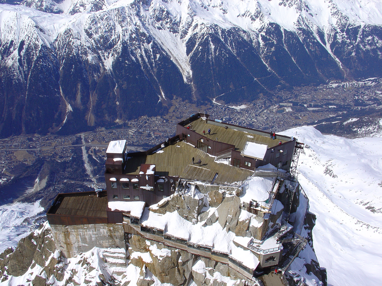

Freeride Added To 2030 Olympic Winter Games
The IOC has today announced a swathe of decisions ahead of the Alpes 2030 Winter Olympics and Paralympics in the French Alps.

Next 3 days weather summary:starker Regen (gesamt 22.0mm), stärkstens währ. der Nacht zu Montag. Sehr mild (maximal 17°C am Montag Nachm., min 12°C am Samstag Morgen). Der Wind bleibt meist schwach.. | Tage 4-6 Chamonix Wetter-Zusammenfassungstarker Regen (gesamt 37.0mm), stärkstens In der Nacht zu Freitag. Sehr mild (maximal 17°C am Dienstag Nachm., min 10°C in der Nacht zu Dienstag). Der Wind bleibt meist schwach.. | |||||||||||||||||
Samstag 1 | Sonntag 2 | Montag 3 | Dienstag 4 | Mittwoch 5 | Donnerstag 6 | |||||||||||||
AM | PM | Nacht | AM | PM | Nacht | AM | PM | Nacht | AM | PM | Nacht | AM | PM | Nacht | AM | PM | Nacht | |
Schauer | Gewitter gefahr | Schauer | klar | Schauer | einige Wolken | klar | Gewitter gefahr | Schauer | klar | Gewitter gefahr | Schauer | klar | Gewitter gefahr | Schauer | klar | Gewitter gefahr | Schauer | |
km/h | ||||||||||||||||||
Schnee Karte |  |  |  |  |  |  | ||||||||||||
— | — | — | — | — | — | — | — | — | — | — | — | — | — | — | — | — | — | |
mm | 1 | 2 | 1 | — | 1 | — | — | 2 | 15 | — | 2 | 20 | — | 3 | 8 | — | 3 | 1 |
max °C | 13 | 14 | 13 | 14 | 16 | 15 | 16 | 17 | 13 | 15 | 17 | 13 | 15 | 15 | 13 | 14 | 15 | 14 |
min °C | 12 | 14 | 12 | 12 | 15 | 13 | 14 | 13 | 12 | 13 | 15 | 10 | 13 | 15 | 12 | 13 | 15 | 13 |
chill °C | 11 | 14 | 12 | 12 | 15 | 13 | 14 | 13 | 12 | 13 | 15 | 10 | 13 | 15 | 12 | 13 | 15 | 13 |
Feuchte % | 61 | 66 | 48 | 51 | 50 | 53 | 45 | 77 | 61 | 56 | 69 | 63 | 59 | 70 | 66 | 61 | 69 | 55 |
Gefrierpunkt m | 4350 | 4400 | 4550 | 4400 | 4600 | 4650 | 4650 | 4550 | 4600 | 4550 | 4650 | 4550 | 4450 | 4550 | 4500 | 4400 | 4450 | 4600 |
6:13 | — | — | 6:15 | — | — | 6:16 | — | — | 6:16 | — | — | 6:18 | — | — | 6:20 | — | — | |
— | — | 9:01 | — | — | 9:00 | — | — | 9:00 | — | — | 8:58 | — | — | 8:57 | — | — | 8:54 | |
Werde Profi und carve ein:
Lawineninformationen: European Avalanche Warning Services (EAWS)
Letzte Schneeberichte in der Nähe von Chamonix:
| Die obere Schneetiefe ist: | — |
|---|---|
| Die untere Schneetiefe ist: | — |
| Neuschneetiefe Berg | — |
| Wann hat es das letzte Mal geschneit? | 10 Jun 2026 |
0.0 | Bluebird Powder Tage Frischer Schnee, meist sonnig, leichter Wind. |
|---|---|
0.0 | Pulverschneetage Neuschnee, bewölkt, Wind |
0.0 | Bluebird Tage Schnee, meist sonnig, leichter Wind. |
Die Tabelle oben zeigt die Wettervorhersage für Chamonix auf der angegebenen Höhe von 2440 m. Unsere ausgeklügelten Wettermodelle ermöglichen uns die Schneevorhersage für die Gipfel-, Mittel- und Talstationen für Chamonix. Das Fenster über der Tabelle ermöglicht das Abrufen der Wettervorhersage für andere Höhen. Für einen umfassenderen Blick auf das Wetter, siehe die Wetterkarte" von France.Chamonix
Klicken Sie hier, um weitere Informationen über Gefrierpunkte zu erhalten und zu lesen wie wir unsere Temperaturen prognostizieren.
Allgemein 4.1 Basiert auf 56 Abstimmungen und 92 Beurteilungen
This is from a piste skier’s perspective. Despite the smaller individual areas, Chamonix is still great. If you think carefully where to stay, you can use the quick reliable train to easily get to the Grand Montets, Flegere and Le Tour (Valloricine station). The buses are fine and really frequent but the train is easier. The Brevent-Flegere area is big enough to keep you happy for a couple of days and has terrific views. Le Tour (Balme) is better than I remembered. Grands Montets is really missing the top lift that’s being rebuilt. Food on the mountain has improved with more options than I remember from my last trip 10 years ago. Food in town is still really good with loads of choice. It’s easy to get to, I took an overnight bus from Paris which worked well. I arrived at 7, had breakfast in the Plan B hotel by the bus station and was skiing by 9. If that’s too extreme, Geneva airport is just over an hour away and there are good train services from Paris. If you’re a piste skier who occasionally ventures off-piste, Chamonix is poor as there are so many good powder skiers it gets tracked out in no time. The great off-piste is well away from the ski areas and quite serious.
Martin aus United Kingdom schreibt:
This is from a piste skier’s perspective. Despite the smaller individual areas, Chamonix is still great. If you think carefully where to stay, you can use the quick reliable train to easily get to the Grand Montets, Flegere and Le Tour (Valloricine station). The buses are fine and really frequent but the train is easier.
The Brevent-Flegere area is big enough to keep you happy for a couple of days and has terrific views. Le Tour (Balme) is better than I remembered. Grands Montets is really missing the top lift that’s being rebuilt.
Food on the mountain has improved with more options than I remember from my last trip 10 years ago. Food in town is still really good with loads of choice.
It’s easy to get to, I took an overnight bus from Paris which worked well. I arrived at 7, had breakfast in the Plan B hotel by the bus station and was skiing by 9. If that’s too extreme, Geneva airport is just over an hour away and there are good train services from Paris.
If you’re a piste skier who occasionally ventures off-piste, Chamonix is poor as there are so many good powder skiers it gets tracked out in no time. The great off-piste is well away from the ski areas and quite serious.
Lesen Sie 91 andere Beurteilungen ueber Chamonix oder geben Sie Ihre eigene Bewertung ab.


 Nearest