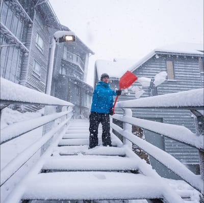
"March Madness" As Snowfall Hits Australia In Early Autumn
Winter made an early-season entrance in Australia overnight, with a polar blast from the Antarctic dumping up to 15cm of fresh snow on the slopes as temperatures tumbled to around -2.C.

Polsa-San Valentino Weather (Next 3 days): The snow forecast for Polsa-San Valentino is: leichter Regen (gesamt 2.0mm), meistens fallend am Montag Nachm.. Frost-Tau-Bedingungen (maximal 4°C am Montag Nachm., min -3°C in der Nacht zu Dienstag). Wind schwächt ab.
Polsa-San Valentino Weather (Days 4-6): Meist trocken. Milde Temperaturen (maximal 6°C am Donnerstag Nachm., min 2°C am Donnerstag Morg.). Wind schwächt ab.
| Höhenlage | Schneehöhe | Temp. (°C) | Wind (km/h) | Wetter | ||
|---|---|---|---|---|---|---|
| Bergstation: | 2 | |||||
| Mittelstation: | 3 | |||||
| Tal: | 1 |

Monday 30 | Tuesday 31 | Wednesday 1 | Thursday 2 | Friday 3 | Saturday 4 | |||||||||||||
AM | PM | Nacht | AM | PM | Nacht | AM | PM | Nacht | AM | PM | Nacht | AM | PM | Nacht | AM | PM | Nacht | |
klar | Schauer | Schneeschauer | klar | einige Wolken | klar | bewölkt | bewölkt | einige Wolken | einige Wolken | klar | einige Wolken | klar | klar | klar | klar | einige Wolken | klar | |
km/h | ||||||||||||||||||
Snow map |  |  |  |  |  |  | ||||||||||||
— | — | — | — | — | — | — | — | — | — | — | — | — | — | — | — | — | — | |
— | 1 | 1 | — | — | — | — | — | — | — | — | — | — | — | — | — | — | — | |
max °C | 1 | 4 | 2 | -1 | 0 | -1 | -2 | 1 | 1 | 2 | 6 | 5 | 2 | 4 | 3 | 3 | 5 | 4 |
min °C | 0 | 3 | -1 | -2 | 0 | -3 | -3 | 0 | 0 | 2 | 5 | 2 | 2 | 4 | 3 | 2 | 5 | 4 |
-2 | 1 | -6 | -7 | -5 | -9 | -10 | -6 | -6 | -2 | 2 | -1 | -1 | 4 | 3 | 2 | 5 | 3 | |
48 | 26 | 47 | 39 | 33 | 36 | 38 | 38 | 37 | 33 | 36 | 35 | 37 | 58 | 64 | 63 | 70 | 69 | |
1750 | 2050 | 1500 | 1450 | 1600 | 1050 | 1300 | 1750 | 1750 | 2050 | 2450 | 2050 | 1950 | 2250 | 2100 | 2300 | 2550 | 2500 | |
7:01 | — | — | 6:58 | — | — | 6:56 | — | — | 6:54 | — | — | 6:52 | — | — | 6:50 | — | — | |
— | 7:40 | — | — | 7:42 | — | — | 7:43 | — | — | 7:45 | — | — | 7:45 | — | — | 7:46 | — | |
leichter Regen (gesamt 2.0mm), meistens fallend am Montag Nachm.. Frost-Tau-Bedingungen (maximal 4°C am Montag Nachm., min -3°C in der Nacht zu Dienstag). Wind schwächt ab.
Meist trocken. Milde Temperaturen (maximal 6°C am Donnerstag Nachm., min 2°C am Donnerstag Morg.). Wind schwächt ab.
Letzte Schneeberichte in der Nähe von Polsa-San Valentino:
Light rain reported from Caldonazzo wx at 461 metres elevation only 4 kms SSW of Levico Terme Panarotta but it is forecast cold enough for snow at the ski area aus Levico Terme Panarotta
| Die obere Schneetiefe ist: | — |
|---|---|
| Die untere Schneetiefe ist: | — |
| Neuschneetiefe Berg | — |
| Wann hat es das letzte Mal geschneit? | 25 Mar 2026 |
0.2 | Bluebird Powder Tage Frischer Schnee, meist sonnig, leichter Wind. |
|---|---|
0.2 | Pulverschneetage Neuschnee, bewölkt, Wind |
0.6 | Bluebird Tage Schnee, meist sonnig, leichter Wind. |
Die Tabelle oben zeigt die Wettervorhersage für Polsa-San Valentino auf der angegebenen Höhe von 1600 m. Unsere ausgeklügelten Wettermodelle ermöglichen uns die Schneevorhersage für die Gipfel-, Mittel- und Talstationen für Polsa-San Valentino. Das Fenster über der Tabelle ermöglicht das Abrufen der Wettervorhersage für andere Höhen. Für einen umfassenderen Blick auf das Wetter, siehe die Wetterkarte" von Italy.Polsa-San Valentino
Klicken Sie hier, um weitere Informationen über Gefrierpunkte zu erhalten und zu lesen wie wir unsere Temperaturen prognostizieren.


 Nearest