

Global Weekly Snow Roundup #314
Weekly Global Snow News, updated 14 May 2026: Fresh snowfall in Argentina, Australia and Lesotho signals winter’s approach, while Japan maintains the world’s deepest snowpack.

Next 3 days weather summary:Meist trocken. Frost-Tau-Bedingungen (maximal 3°C am Montag Nachm., min -3°C In der Nacht zu Samstag). Wind abnehmend (frische Winde aus SSO am Samstag Morgen, Windstille bis Sonntag Nachm.). | Days 4-6 weather summary:Eine dünne Neuschneedecke. Frost-Tau-Bedingungen (maximal 5°C am Donnerstag Nachm., min -2°C in der Nacht zu Dienstag). Wind zunehmend (Windstille am Dienstag Morg., frische Winde aus SO bis Donnerstag Nacht). | |||||||||||||||||
Saturday 16 | Sunday 17 | Monday 18 | Tuesday 19 | Wednesday 20 | Thursday 21 | |||||||||||||
AM | PM | Nacht | AM | PM | Nacht | AM | PM | Nacht | AM | PM | Nacht | AM | PM | Nacht | AM | PM | Nacht | |
leichter Schnee | leichter Schnee | einige Wolken | klar | einige Wolken | einige Wolken | klar | einige Wolken | einige Wolken | bewölkt | leichter Schnee | Schneeschauer | klar | klar | klar | klar | klar | einige Wolken | |
km/h | ||||||||||||||||||
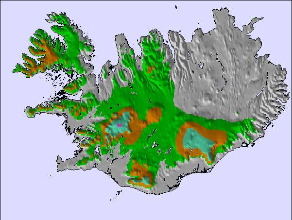
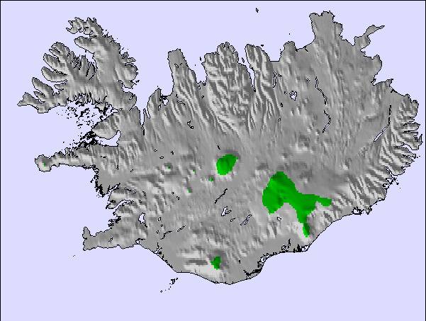
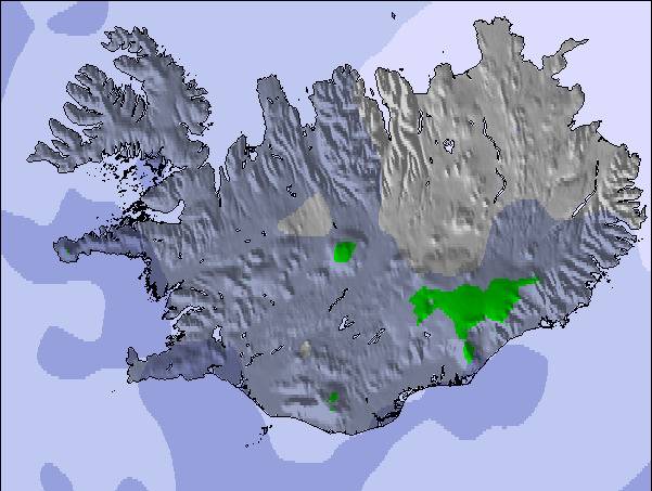
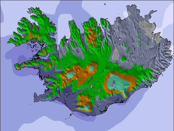
Snow map |  |  |  |  |  |  | ||||||||||||
— | — | — | — | — | — | — | — | — | — | 1 | — | — | — | — | — | — | — | |
— | — | — | — | — | — | — | — | — | — | — | — | — | — | — | — | — | — | |
max °C | -2 | -1 | -2 | -1 | 2 | 1 | 1 | 3 | 2 | 0 | 1 | 0 | 0 | 2 | 2 | 3 | 5 | 3 |
min °C | -2 | -2 | -3 | -2 | 1 | -1 | -1 | 2 | 0 | 0 | 0 | -2 | -1 | 1 | 1 | 3 | 4 | 2 |
-10 | -9 | -6 | -5 | 1 | -3 | -5 | -1 | -2 | 0 | -4 | -7 | -5 | -3 | -1 | 0 | 0 | -4 | |
87 | 92 | 88 | 83 | 66 | 85 | 83 | 63 | 85 | 90 | 91 | 77 | 62 | 62 | 62 | 48 | 60 | 46 | |
850 | 900 | 750 | 850 | 1250 | 1150 | 1100 | 1450 | 1250 | 1100 | 1250 | 1000 | 1000 | 1300 | 1300 | 1550 | 1900 | 1900 | |
3:50 | — | — | 3:47 | — | — | 3:44 | — | — | 3:40 | — | — | 3:36 | — | — | 3:32 | — | — | |
— | — | 10:38 | — | — | 10:43 | — | — | 10:45 | — | — | 10:50 | — | — | 10:52 | — | — | 10:57 | |
Letzte Schneeberichte in der Nähe von Kerlingarfjöll:
| Die obere Schneetiefe ist: | — |
|---|---|
| Die untere Schneetiefe ist: | — |
| Neuschneetiefe Berg | — |
| Wann hat es das letzte Mal geschneit? | 10 May 2026 |
0.1 | Bluebird Powder Tage Frischer Schnee, meist sonnig, leichter Wind. |
|---|---|
1.0 | Pulverschneetage Neuschnee, bewölkt, Wind |
1.7 | Bluebird Tage Schnee, meist sonnig, leichter Wind. |
Die Tabelle oben zeigt die Wettervorhersage für Kerlingarfjöll auf der angegebenen Höhe von 1150 m. Unsere ausgeklügelten Wettermodelle ermöglichen uns die Schneevorhersage für die Gipfel-, Mittel- und Talstationen für Kerlingarfjöll. Das Fenster über der Tabelle ermöglicht das Abrufen der Wettervorhersage für andere Höhen. Für einen umfassenderen Blick auf das Wetter, siehe die Wetterkarte" von Iceland.Kerlingarfjöll
Klicken Sie hier, um weitere Informationen über Gefrierpunkte zu erhalten und zu lesen wie wir unsere Temperaturen prognostizieren.
Skigebietsname wird auch Kerlingarfjoll.geschrieben.
The lifts have rusted, the snow is virgin, spring skiing via telemark - mountain equipment par excellence. The roads are difficult until mid June; conditions good until mid July. Terrain: difficult to reach, difficult to ski. The huts are heaven in a desert and the hostesses: inspiring?
Terrrence Trow aus United States schreibt:
The lifts have rusted, the snow is virgin, spring skiing via telemark - mountain equipment par excellence. The roads are difficult until mid June; conditions good until mid July. Terrain: difficult to reach, difficult to ski. The huts are heaven in a desert and the hostesses: inspiring?
Klicken Sie hier um Ihre eigene Beurteilung über Kerlingarfjöll abzugeben

 Nearest