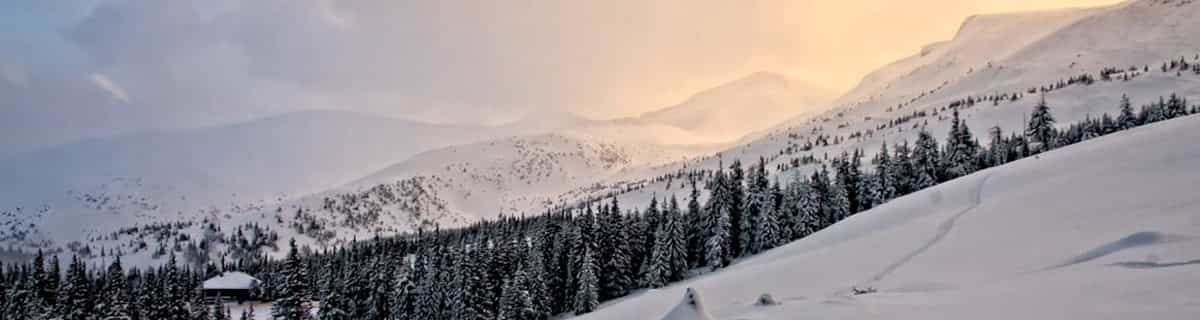


Global Weekly Snow Roundup #314
Weekly Global Snow News, updated 14 May 2026: Fresh snowfall in Argentina, Australia and Lesotho signals winter’s approach, while Japan maintains the world’s deepest snowpack.

Next 3 days weather summary:leichter Regen (gesamt 5.0mm), meistens fallend am Samstag Nachm.. Milde Temperaturen (maximal 7°C am Montag Nachm., min 1°C am Samstag Morgen). Wind schwächt ab. | Days 4-6 weather summary:starker Regen (gesamt 24.0mm), stärkstens währ. Dienstag Nnachm.. Milde Temperaturen (maximal 8°C in der Nacht zu Dienstag, min 6°C in der Nacht zu Donnerstag). Wind schwächt ab. | |||||||||||||||||
Saturday 16 | Sunday 17 | Monday 18 | Tuesday 19 | Wednesday 20 | Thursday 21 | |||||||||||||
AM | PM | Nacht | AM | PM | Nacht | AM | PM | Nacht | AM | PM | Nacht | AM | PM | Nacht | AM | PM | Nacht | |
leichter Schnee | etwas Regen | bewölkt | einige Wolken | bewölkt | klar | einige Wolken | Schauer | Schauer | etwas Regen | Schauer | Schauer | Schauer | Schauer | etwas Regen | etwas Regen | Schauer | Schauer | |
km/h | ||||||||||||||||||
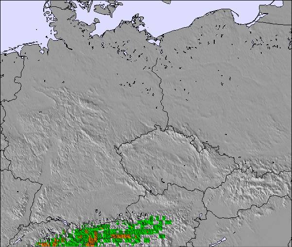
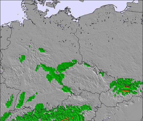
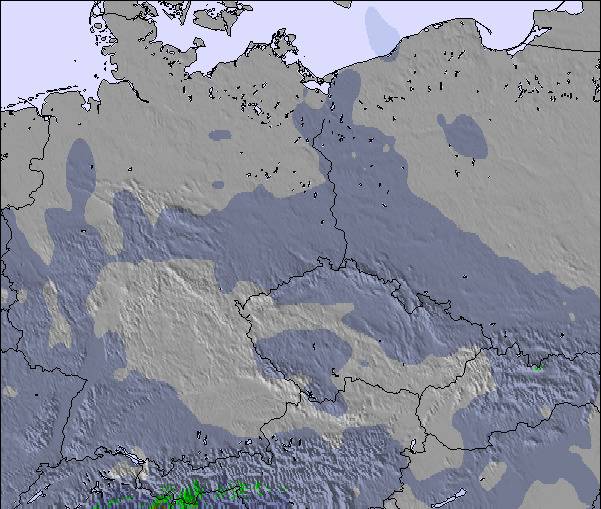
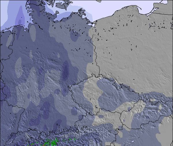
Snow map | 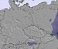 | 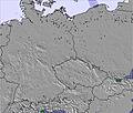 | 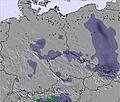 | 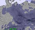 | 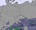 | 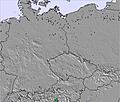 | ||||||||||||
— | — | — | — | — | — | — | — | — | — | — | — | — | — | — | — | — | — | |
— | 2 | — | — | — | — | — | 2 | 1 | 1 | 8 | 3 | 1 | 2 | 1 | 4 | 3 | 1 | |
max °C | 1 | 3 | 3 | 3 | 5 | 4 | 6 | 7 | 7 | 7 | 7 | 8 | 7 | 8 | 8 | 8 | 8 | 8 |
min °C | 1 | 2 | 2 | 2 | 4 | 4 | 4 | 6 | 7 | 7 | 7 | 7 | 7 | 7 | 7 | 8 | 8 | 6 |
-4 | -2 | -2 | -1 | 4 | 4 | 4 | 6 | 7 | 7 | 7 | 6 | 6 | 5 | 3 | 5 | 4 | 2 | |
98 | 79 | 70 | 62 | 76 | 65 | 66 | 76 | 70 | 84 | 87 | 75 | 88 | 90 | 92 | 92 | 91 | 65 | |
1550 | 1800 | 1750 | 1850 | 1900 | 2000 | 2100 | 2250 | 2350 | 2300 | 2400 | 2400 | 2450 | 2650 | 2550 | 2550 | 2750 | 2950 | |
5:07 | — | — | 5:05 | — | — | 5:03 | — | — | 5:03 | — | — | 5:01 | — | — | 5:00 | — | — | |
— | — | 8:39 | — | — | 8:40 | — | — | 8:42 | — | — | 8:44 | — | — | 8:45 | — | — | 8:46 | |
Letzte Schneeberichte in der Nähe von Karpacz - Kopa:
| Die obere Schneetiefe ist: | — |
|---|---|
| Die untere Schneetiefe ist: | — |
| Neuschneetiefe Berg | — |
| Wann hat es das letzte Mal geschneit? | 12 May 2026 |
0.0 | Bluebird Powder Tage Frischer Schnee, meist sonnig, leichter Wind. |
|---|---|
0.0 | Pulverschneetage Neuschnee, bewölkt, Wind |
0.0 | Bluebird Tage Schnee, meist sonnig, leichter Wind. |
Die Tabelle oben zeigt die Wettervorhersage für Karpacz - Kopa auf der angegebenen Höhe von 1350 m. Unsere ausgeklügelten Wettermodelle ermöglichen uns die Schneevorhersage für die Gipfel-, Mittel- und Talstationen für Karpacz - Kopa. Das Fenster über der Tabelle ermöglicht das Abrufen der Wettervorhersage für andere Höhen. Für einen umfassenderen Blick auf das Wetter, siehe die Wetterkarte" von Poland.Karpacz - Kopa
Klicken Sie hier, um weitere Informationen über Gefrierpunkte zu erhalten und zu lesen wie wir unsere Temperaturen prognostizieren.
Allgemein 3.8 Basiert auf 14 Abstimmungen und 1 Bewertung
Karpacz- Märchen ja, aber kein Wintermärchen! Stand 15.02.2011 Das Skigbiet liegt schön hoch, ist schön gelegen und über einen schönen langen und gefährlichen Aufstieg mit Skischuhen mühsam zu erreichen. Im Sommer bietet es den Zugang zu den Reizen des Riesengebirges. Im Winter bietet es all die Überraschungen, auf die jeder gerne im Urlaub verzichtet. Die Betreiber des Gebietes haben zwei große Feinde. Das ist einerseits der Winter, der oft monatelang und dazu völlig unerwartet mit Schnee, Frost und Stürmen antritt. Dann schrumpfen regelmäßig 5km Piste auf 1,5km zusammen, obwohl nach Liftbetreiber 6km präpariert sind. Hierzu gehört neben Liczyrzepa auch Jan, Lifte, der seit Jahren nicht mehr laufen und zu den besten Abfahrten gehören. Auf den Pisten wachsen Sträucher und Gehölze, die wohl ersatzweise präpariert werden. Der zweite Feind ist das bewegungslose Personal. Gemeinde und Liftbetreiber präsentieren eben nicht dass, was sie haben, sondern das, was sie gerne gewinnbringend hätten. Trotzdem sollten Sie Karpacz im Winter nicht meiden, den „Berg Kopa“ aber schon. Denn Karpacz hat sehr viel zu bieten. Die Menschen sind freundlich, höflich, hilfsbereit und gute Gastgeber. Die Natur ist toll. Karpacz hat ein Problem mit dem Naturschutz. Skilaufen nein, auch keinen Langlauf, auch keine Rodelbahnen, außer auf dem Papier. Nein, nur Motorsport. Für einen Berliner kaum zu verstehen. Naturschutz kann aber nicht heißen, dass jeder Gast im Winter 24 Stunden im Hotel bleibt. Der Skiläufer findet jedoch in Karpacz eine Straße, die über Kowary nach Mala Upa führt. Diese Straße sollte er nutzen, denn hier findet er all das zu angemessenen Preisen, was Karpacz nur verspricht. Da gibt es sogar richtige Berghütten mit Toiletten. Hier beginnt ein Paradies für Wintersportler aller Art. Da gibt es sogar Sprungschanzen auf denen gesprungen wird und nicht nur ein verfallenes Denkmal aus dem Jahr 2004 mit Namen Olinek, welches schon am Tag der Einweihung lebendig begraben wurde. Es gibt in Polen, nicht weit von Karpacz ein weiteres Skigebiet, welches vom ADAC getestet wurde. Das Ergebnis war nicht berauschend und lautete: sehr mangelhaft. Trotzdem wären nicht nur die Einheimischen froh, wenn „die Kopa“ die Qualität vom Skigebiet in Sklarska Poreba auch nur annähernd aufweisen könnte. Bei denen geht es sogar voran, stetig! „Die Kopa“ wird wohl wie die Sprungschanze enden. Potemkinsche Dörfer werden nicht für die Zukunft gebaut. Zum 01.03.2011 werden die Eintrittskarten zum Skigebietsmärchen bis zu 50% gesenkt. Die Formulierung ist falsch. Eigentlich müsste es heißen: „Die Verluste beim Kauf einer Eintrittskarte werden drastisch gesenkt. Skipass möchte ich nicht sagen. Zum Skipass gehört ein Skigebiet. Finanziell kompensiert wird dieses Vorhaben durch die Erhöhung der Abgaben an die Gemeinde für Pensionen und Hotels, die im Winter weitgehend leer stehen und die trotzdem, gleich einem Wunder, wie Pilze aus der Erde schießen. Denn die Abgabe an die Gemeinde wird nach Quadratmetern berechnet. Rechte Tasche, linke Tasche. Investitionsruine Karpacz. Ein falsches Märchen, kein Wintertraum, eher ein Alptraum und sicheres, gewinnträchtiges Zlotygrab. Peter Rutke am 15.02.2011
peter Rutke aus Germany schreibt:
Karpacz- Märchen ja, aber kein Wintermärchen! Stand 15.02.2011
Das Skigbiet liegt schön hoch, ist schön gelegen und über einen schönen langen und gefährlichen Aufstieg mit Skischuhen mühsam zu erreichen. Im Sommer bietet es den Zugang zu den Reizen des Riesengebirges. Im Winter bietet es all die Überraschungen, auf die jeder gerne im Urlaub verzichtet.
Die Betreiber des Gebietes haben zwei große Feinde. Das ist einerseits der Winter, der oft monatelang und dazu völlig unerwartet mit Schnee, Frost und Stürmen antritt. Dann schrumpfen regelmäßig 5km Piste auf 1,5km zusammen, obwohl nach Liftbetreiber 6km präpariert sind. Hierzu gehört neben Liczyrzepa auch Jan, Lifte, der seit Jahren nicht mehr laufen und zu den besten Abfahrten gehören. Auf den Pisten wachsen Sträucher und Gehölze, die wohl ersatzweise präpariert werden.
Der zweite Feind ist das bewegungslose Personal. Gemeinde und Liftbetreiber präsentieren eben nicht dass, was sie haben, sondern das, was sie gerne gewinnbringend hätten.
Trotzdem sollten Sie Karpacz im Winter nicht meiden, den „Berg Kopa“ aber schon. Denn Karpacz hat sehr viel zu bieten. Die Menschen sind freundlich, höflich, hilfsbereit und gute Gastgeber. Die Natur ist toll. Karpacz hat ein Problem mit dem Naturschutz. Skilaufen nein, auch keinen Langlauf, auch keine Rodelbahnen, außer auf dem Papier. Nein, nur Motorsport. Für einen Berliner kaum zu verstehen. Naturschutz kann aber nicht heißen, dass jeder Gast im Winter 24 Stunden im Hotel bleibt.
Der Skiläufer findet jedoch in Karpacz eine Straße, die über Kowary nach Mala Upa führt. Diese Straße sollte er nutzen, denn hier findet er all das zu angemessenen Preisen, was Karpacz nur verspricht.
Da gibt es sogar richtige Berghütten mit Toiletten. Hier beginnt ein Paradies für Wintersportler aller Art. Da gibt es sogar Sprungschanzen auf denen gesprungen wird und nicht nur ein verfallenes Denkmal aus dem Jahr 2004 mit Namen Olinek, welches schon am Tag der Einweihung lebendig begraben wurde.
Es gibt in Polen, nicht weit von Karpacz ein weiteres Skigebiet, welches vom ADAC getestet wurde. Das Ergebnis war nicht berauschend und lautete: sehr mangelhaft. Trotzdem wären nicht nur die Einheimischen froh, wenn „die Kopa“ die Qualität vom Skigebiet in Sklarska Poreba auch nur annähernd aufweisen könnte. Bei denen geht es sogar voran, stetig!
„Die Kopa“ wird wohl wie die Sprungschanze enden. Potemkinsche Dörfer werden nicht für die Zukunft gebaut. Zum 01.03.2011 werden die Eintrittskarten zum Skigebietsmärchen bis zu 50% gesenkt. Die Formulierung ist falsch. Eigentlich müsste es heißen: „Die Verluste beim Kauf einer Eintrittskarte werden drastisch gesenkt. Skipass möchte ich nicht sagen. Zum Skipass gehört ein Skigebiet. Finanziell kompensiert wird dieses Vorhaben durch die Erhöhung der Abgaben an die Gemeinde für Pensionen und Hotels, die im Winter weitgehend leer stehen und die trotzdem, gleich einem Wunder, wie Pilze aus der Erde schießen. Denn die Abgabe an die Gemeinde wird nach Quadratmetern berechnet. Rechte Tasche, linke Tasche. Investitionsruine Karpacz. Ein falsches Märchen, kein Wintertraum, eher ein Alptraum und sicheres, gewinnträchtiges Zlotygrab.
Peter Rutke am 15.02.2011
Klicken Sie hier um Ihre eigene Beurteilung über Karpacz - Kopa abzugeben

 Nearest