

Global Weekly Snow Roundup #314
Weekly Global Snow News, updated 14 May 2026: Fresh snowfall in Argentina, Australia and Lesotho signals winter’s approach, while Japan maintains the world’s deepest snowpack.

Next 3 days weather summary:mäßiger Schneefall, stärkstens am Samstag Morgen. Temperaturen werden unter dem Gefrierpunkt sein (maximal -3°C in der Nacht zu Sonntag, min -11°C am Samstag Morgen). Wind schwächt ab. | Days 4-6 weather summary:Eine dünne Neuschneedecke. Frost-Tau-Bedingungen (maximal 3°C in der Nacht zu Donnerstag, min -4°C am Dienstag Morg.). Wind zunehmend (Windstille am Dienstag Morg., frische Winde aus Westen bis Mittwoch Abend). | |||||||||||||||||
Saturday 16 | Sunday 17 | Monday 18 | Tuesday 19 | Wednesday 20 | Thursday 21 | |||||||||||||
AM | PM | Nacht | AM | PM | Nacht | AM | PM | Nacht | AM | PM | Nacht | AM | PM | Nacht | AM | PM | Nacht | |
leichter Schnee | leichter Schnee | Schneeschauer | klar | Schneeschauer | Schneeschauer | Schneeschauer | leichter Schnee | leichter Schnee | einige Wolken | Schneeschauer | leichter Schnee | leichter Schnee | Schneeschauer | leichter Schnee | einige Wolken | klar | klar | |
km/h | ||||||||||||||||||
Snow map |  |  |  |  |  |  | ||||||||||||
3 | 2 | — | — | — | — | — | 3 | 4 | — | — | 2 | — | 1 | — | — | — | — | |
— | — | — | — | — | — | — | — | — | — | — | — | — | — | — | — | — | — | |
max °C | -11 | -9 | -8 | -6 | -5 | -3 | -4 | -4 | -5 | -3 | -3 | -3 | -2 | -1 | -1 | 0 | 1 | 3 |
min °C | -11 | -10 | -9 | -8 | -6 | -5 | -5 | -4 | -5 | -4 | -3 | -3 | -3 | -1 | -1 | -1 | 0 | 2 |
-18 | -15 | -16 | -12 | -8 | -5 | -5 | -4 | -10 | -6 | -6 | -7 | -10 | -7 | -8 | -7 | -4 | -3 | |
92 | 92 | 78 | 48 | 76 | 71 | 88 | 97 | 85 | 61 | 88 | 97 | 90 | 72 | 87 | 50 | 81 | 36 | |
1450 | 1800 | 1600 | 2000 | 2400 | 2250 | 2400 | 2350 | 2050 | 2500 | 2650 | 2500 | 2600 | 2900 | 2750 | 2900 | 3050 | 3400 | |
5:39 | — | — | 5:37 | — | — | 5:35 | — | — | 5:35 | — | — | 5:33 | — | — | 5:33 | — | — | |
— | — | 8:45 | — | — | 8:47 | — | — | 8:49 | — | — | 8:50 | — | — | 8:51 | — | — | 8:52 | |
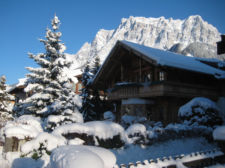
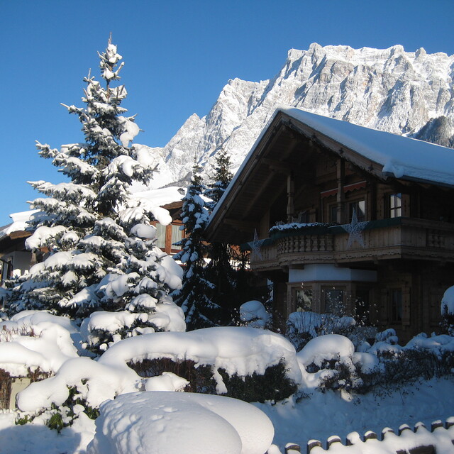
Letzte Schneeberichte in der Nähe von Ehrwald:
| Die obere Schneetiefe ist: | — |
|---|---|
| Die untere Schneetiefe ist: | — |
| Neuschneetiefe Berg | 21 cm |
| Wann hat es das letzte Mal geschneit? | 15 May 2026 |
0.4 | Bluebird Powder Tage Frischer Schnee, meist sonnig, leichter Wind. |
|---|---|
1.3 | Pulverschneetage Neuschnee, bewölkt, Wind |
1.0 | Bluebird Tage Schnee, meist sonnig, leichter Wind. |


Die Tabelle oben zeigt die Wettervorhersage für Ehrwald auf der angegebenen Höhe von 2964 m. Unsere ausgeklügelten Wettermodelle ermöglichen uns die Schneevorhersage für die Gipfel-, Mittel- und Talstationen für Ehrwald. Das Fenster über der Tabelle ermöglicht das Abrufen der Wettervorhersage für andere Höhen. Für einen umfassenderen Blick auf das Wetter, siehe die Wetterkarte" von Austria.Ehrwald
Klicken Sie hier, um weitere Informationen über Gefrierpunkte zu erhalten und zu lesen wie wir unsere Temperaturen prognostizieren.
Allgemein 3.6 Basiert auf 11 Abstimmungen und 4 Beurteilungen
Oh, Ehrwald is amazing. Slopes were great and Zugspitze was very good. Pretty high up but was good so would definitely go back.
CH aus United Kingdom schreibt:
Oh, Ehrwald is amazing. Slopes were great and Zugspitze was very good. Pretty high up but was good so would definitely go back.
Lesen Sie 3 andere Beurteilungen ueber Ehrwald oder geben Sie Ihre eigene Bewertung ab.


 Nearest