

Global Weekly Snow Roundup #314
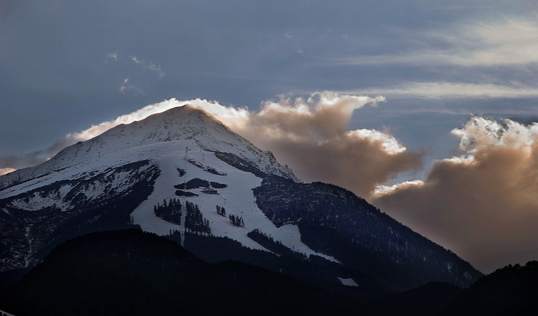
Weekly Global Snow News, updated 14 May 2026: Fresh snowfall in Argentina, Australia and Lesotho signals winter’s approach, while Japan maintains the world’s deepest snowpack.

Next 3 days weather summary:Mild mit leichtem Regen (gesamt 6.0mm) am Samstag Nachm. kälter mit leichtem Schneebestreuung, fallend meistens In der Nacht zu Samstag. Frost-Tau-Bedingungen (maximal 3°C am Samstag Nachm., min -3°C In der Nacht zu Samstag). Wind abnehmend (frische Winde aus WNW In der Nacht zu Samstag, Windstille bis Montag Nachm.). | Days 4-6 weather summary:Sehr leichter Schneefall. Später milder mit starkem Regen (gesamt 23.0mm) in der Nacht zu Mittwoch. Temperaturen werden etwas über dem Gefrierpunkt sein (maximal 3°C am Mittwoch Nachm., min 1°C am Dienstag Morg.). Wind schwächt ab. | |||||||||||||||||
Saturday 16 | Sunday 17 | Monday 18 | Tuesday 19 | Wednesday 20 | Thursday 21 | |||||||||||||
AM | PM | Nacht | AM | PM | Nacht | AM | PM | Nacht | AM | PM | Nacht | AM | PM | Nacht | AM | PM | Nacht | |
Schauer | Gewittergefahr | Schneeschauer | Schneeschauer | Schneeschauer | einige Wolken | einige Wolken | bewölkt | einige Wolken | leichter Schnee | etwas Regen | leichter Schnee | leichter Schnee | mäßiger Regen | leichter Schnee | etwas Regen | mäßiger Regen | Schauer | |
km/h | ||||||||||||||||||
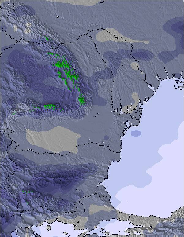
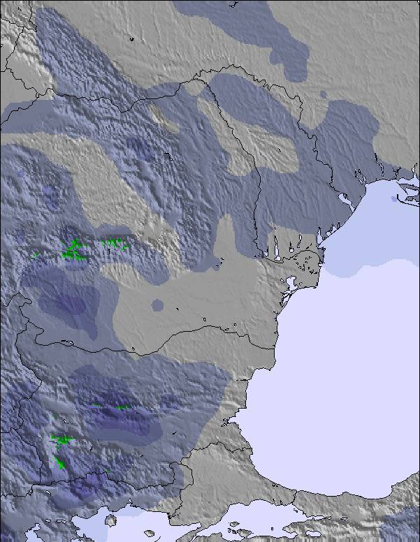
Snow map | 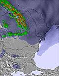 | 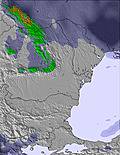 | 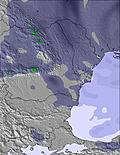 | 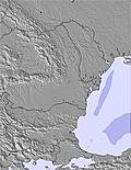 | 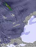 | 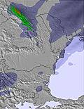 | ||||||||||||
— | — | 8 | — | — | — | — | — | — | — | — | 1 | 1 | — | 1 | — | — | — | |
1 | 5 | — | — | — | — | — | — | — | — | 3 | — | — | 6 | 4 | 2 | 7 | 1 | |
max °C | 2 | 3 | 0 | -2 | 0 | 0 | 1 | 1 | 1 | 1 | 2 | 2 | 2 | 3 | 2 | 2 | 2 | 2 |
min °C | 2 | 2 | -3 | -3 | -1 | -1 | 0 | 1 | 0 | 1 | 2 | 1 | 1 | 3 | 1 | 2 | 2 | 1 |
-2 | -3 | -11 | -10 | -7 | -6 | 0 | 1 | 0 | 1 | 2 | -2 | -2 | 3 | 0 | 0 | 0 | -3 | |
73 | 75 | 61 | 86 | 84 | 78 | 78 | 87 | 82 | 83 | 86 | 91 | 91 | 89 | 94 | 91 | 97 | 96 | |
2850 | 2900 | 2550 | 2250 | 2450 | 2550 | 2650 | 2750 | 2700 | 2650 | 2850 | 2800 | 2750 | 3000 | 2900 | 2850 | 3000 | 2850 | |
6:05 | — | — | 6:05 | — | — | 6:03 | — | — | 6:03 | — | — | 6:01 | — | — | 6:01 | — | — | |
— | 8:38 | — | — | 8:39 | — | — | 8:40 | — | — | 8:42 | — | — | 8:43 | — | — | 8:44 | — | |
Letzte Schneeberichte in der Nähe von Bansko:
| Die obere Schneetiefe ist: | — |
|---|---|
| Die untere Schneetiefe ist: | — |
| Neuschneetiefe Berg | — |
| Wann hat es das letzte Mal geschneit? | 2 May 2026 |
0.1 | Bluebird Powder Tage Frischer Schnee, meist sonnig, leichter Wind. |
|---|---|
0.4 | Pulverschneetage Neuschnee, bewölkt, Wind |
0.2 | Bluebird Tage Schnee, meist sonnig, leichter Wind. |
Die Tabelle oben zeigt die Wettervorhersage für Bansko auf der angegebenen Höhe von 2600 m. Unsere ausgeklügelten Wettermodelle ermöglichen uns die Schneevorhersage für die Gipfel-, Mittel- und Talstationen für Bansko. Das Fenster über der Tabelle ermöglicht das Abrufen der Wettervorhersage für andere Höhen. Für einen umfassenderen Blick auf das Wetter, siehe die Wetterkarte" von Bulgaria.Bansko
Klicken Sie hier, um weitere Informationen über Gefrierpunkte zu erhalten und zu lesen wie wir unsere Temperaturen prognostizieren.
Allgemein 3.6 Basiert auf 220 Abstimmungen und 362 Beurteilungen
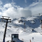
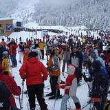
Last day of a 2 week stay this year and not much has changed. The gondola queue is crazy if you're not there between 7.45 and 8.15 when you'll walk straight on. Arrive at 9 and you'll be standing around for over an hour. The ski area hasn't changed and is still good. Lift pass prices are high at €59 per day, at least when you consider what that money gets you in terms of ski area. I was also disappointed by the 'discount' for buying longer passes, it wasn't really worth it when considering the rule of the pass being valid for consecutive days rather than days skiing. In town is much the same, nasty up top, traditional and lovely in town. I worried I might be bored staying two weeks but had a great time. I'd do it again next year.
Sean aus United Kingdom schreibt:
Last day of a 2 week stay this year and not much has changed. The gondola queue is crazy if you're not there between 7.45 and 8.15 when you'll walk straight on. Arrive at 9 and you'll be standing around for over an hour. The ski area hasn't changed and is still good. Lift pass prices are high at €59 per day, at least when you consider what that money gets you in terms of ski area. I was also disappointed by the 'discount' for buying longer passes, it wasn't really worth it when considering the rule of the pass being valid for consecutive days rather than days skiing. In town is much the same, nasty up top, traditional and lovely in town. I worried I might be bored staying two weeks but had a great time. I'd do it again next year.
Lesen Sie 361 andere Beurteilungen ueber Bansko oder geben Sie Ihre eigene Bewertung ab.


 Nearest